
PreFlood| Rising Water
Project Details
The Challenge | Rising Water
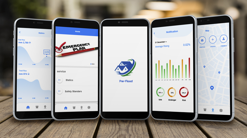
Pre-Flood
We will create an application targeting coastal residents or their friends to alert them in case of high water level and record the results periodically by sensors installed at different distances inside the oceans.
- overview
We chose one of the Earth Oceans challenges which is Rising Water that concerned about water-rising level due to different environmental circumstances and its risks to coastal areas. Because of that, we identified the most vulnerable areas at flood risks, which are Mumbai (India), Gwangju and Shanghai(china), Miami (USA), Vietnam, Calcutta (India), New York (USA), Osaka Kobe (Japan), Alexandria (Egypt), New Orleans (USA) respectively ranked according to previous studies conducted in 2005. In our application, we targeted Osaka Kobe in Japan.[1]
- Motivation
A humanitarian motive led us to help the people of the coastal areas to avoid sudden floods that have bloody results, thus reducing the human losses resulting from it, and raising the awareness of the people of the coastal areas about the expected dangers ahead of a certain time in order to save their lives, this application may have an important role in the return Movement of tourists in those. In addition, Reducing the damage caused by rising water level, maintaining the safety of coastal residents and knowing the changes that occur unnoticed to the population and inform them.
- Problems
- High water level due to various environmental factors (global warming, high annual rainfall, ice collapse due to high temperature).
- Approximately 40% of the world's population lives in coastal areas, that leads to an inevitable danger.
- high water level at a rate of 3 mm per year.
- Results associated with sea level rise as the disappearance of entire coasts with its inhabitants.[2]
- solution
- Install sensors in the oceans to be recorded periodical readings of the water level so that they are sent to users every specific period of time and send special notice in case of a significant rise in water level.
- Clarify safety and flood protection guidelines to help people in coastal areas and rely on periodic readings to find out the water level.
- Solve the problem of rising water level is difficult to be within the characteristics of the application because this problem is linked to other environmental problems, including global warming associated with human behaviors, so we will provide a property to educate users about the causes of rising water levels and ways to avoid them.
- Mitigate the impact resulting from the rise in the level of water by Equip the infrastructure to withstand the potential flood problem.
- Mechanism Of Action
- Fixing the sensors in different areas with fixed distances between each sensor and the other at a fixed height so that it will record periodic readings (each specific time takes new readings) of the water level.
- The readings will be divided into 3 possibilities and each probability indicates a different level of risk and will be divided as follows :
- green level which indicates a slight rise in the water level and there is no risk of flooding soon.
- yellow level which indicates the need to start taking safety measures Because there is a risk of flooding soon.
-red level indicates that there will be a flood and coastal areas should be evacuated as soon as possible
3. There will be an application for the inhabitants of coastal areas to show the readings recorded by the sensor to be in direct contact with the sensor and know the water level.
4. There are special instructions in the case of the possibility of an upcoming flood must be followed to facilitate and accelerate the process of evacuation to be quick and safe.
5. The user must enter his location on the map. After that, he will know the areas near it that prone to flooding. That can be used by relatives of a person living in a coastal area to know the readings available.
- References
[1] Statistics of the countries most at risk of flooding (In 2005)