
uGrace Anatomy| Rising Water
Project Details
Awards & Nominations
uGrace Anatomy has received the following awards and nominations. Way to go!
The Challenge | Rising Water
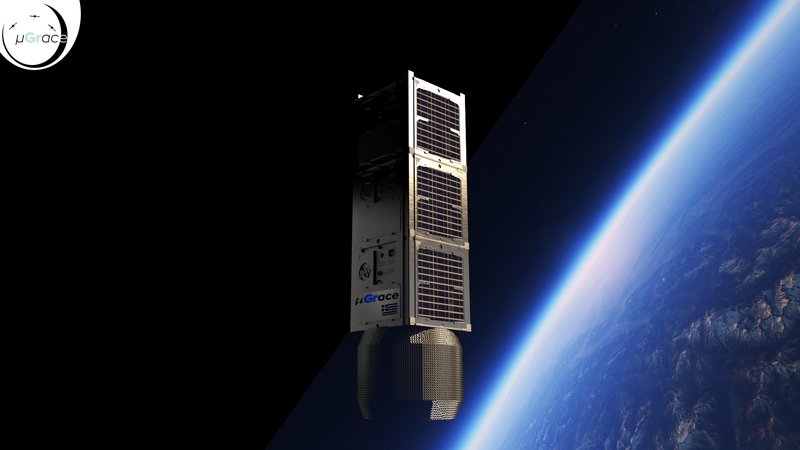
uGrace
Tracking Earth's underground water is a vital task. Missions like Grace, focus on global coverage, while our idea is a similar mission using 3 small sats, at a custom orbit increasing the resolution to 25km for a specific area of interest at low cost.
Project's gitlab page https://gitlab.com/vpetrog/ugrace-nasa-spaceapp-ch...
Because of many mathematical equations, tables and images please refer to the attached final report
1. Thinking outside the box…
The underground waters. Groundwater is the water present beneath Earth's surface in soil pore spaces and in fractures of rock formations. This water body is stored in underground reservoirs called Aquifers. Despite the fact that this mass accounts only for 0.61 % of the entire world’s water, it composes approximately 20 % of the planet’s freshwater reservoir.
It is naturally replenished by surface water from precipitation, streams, and rivers when this recharge reaches the water table. However, human caused phenomena, such as overdrafting, and natural incidents, like subsidence or the desalinization that is induced from the intrusion of the saltwater when the natural water flow is reversed, make the monitoring of the underground waters an extremely important priority.
2. Tracking Underground Water. Why?
2.1. Social Impact
The social impact of studying underground waters emerges from the fact that, according to the World Health Organization, more than 1/3 of the Earth’s population overuses its freshwater repositories and the rest (2/3) have no access to water supplies or to doubtful quality water. Hence, the World Economic Forum (WEF) Global Risk Reports identified water as the top important challenge worldwide with the biggest social and economic risk of the decade.
2.2. Investment Opportunities
Many Institutions and research centres around the world require a macroscopic analysis of the underground water system for a particular area of interest. A case study that was used as a proof of concept for our idea, is the Hellenic Survey of Geology & Mineral Exploration (HSGME). According to them, there are areas of Greece that need to be monitored. One such example is the Valley of Thessaly. This valley has an area of 14,036.64 km2 and is the biggest source of agricultural products in Greece. Unfortunately, it suffers from the following problems and risks:
- Desertification
- Salinization
Currently, experts are trying to create trends and predictions, but the lack of macroscopic data is limiting their progress. Data are collected using drilling surveys and excavations which provide extremely localised data (<200 m Radius). Moreover, the network doesn’t support telemetry, thus the data are very sparse. Cost-wise for these 1800 drilling stations, a 10M$ investment is required and even so the problem will not be completely solved.
Furthermore, the Private sector could be benefited from such a mission. For instance, agricultural companies could test the underground water reservoirs of an area, so they can choose the appropriate crops.
3. Current Solutions
3.1. Grace & Grace FO
GRACE Follow-On (GRACE-FO) is continuing GRACE’s legacy of tracking Earth’s water movement across the planet. Monitoring changes in ice sheets and glaciers, underground water storage, the amount of water in large lakes and rivers, and changes in sea level provide a unique view of Earth’s climate and has far-reaching benefits for its people.
Two satellites travel along the same orbit, one about 220 kilometres behind the other. As the lead satellite approaches a region with high mass, such as a mountain range, the higher gravitational tugs the satellite a little farther ahead of the following satellite. Moments later, the following satellite is pulled forward in its turn, shortening the distance between them. When the leading satellite moves past the mountains, their high mass drags at it from behind, narrowing, again, the gap between the two satellites. Both satellites constantly send microwave signals to each other, precisely measuring the changes in distance between them. “Precisely” is the key word: the measurement is accurate to within a few microns, about the thickness of a blood cell. A highly accurate accelerometer, located at each satellite’s centre of mass, measures accelerations caused by anything other than gravity, such as atmospheric drag. Satellite GPS receivers determine the exact position of the satellites in orbit around the Earth.
3.2. GOCE
The Gravity Field and Steady-State Ocean Circulation Explorer (GOCE) was the first of ESA's Living Planet Program satellites intended to map in unprecedented detail the Earth's gravity field. The spacecraft's primary instrumentation was a highly sensitive gravity gradiometer consisting of three pairs of accelerometers which measured gravitational gradients along three orthogonal axes.
It mapped the deep structure of the Earth's mantle and probed hazardous volcanic regions. It brought new insight into ocean behaviour; this in particular was a major driver for the mission. By combining the gravity data with information about sea surface height gathered by other satellite altimeters, scientists were able to track the direction and speed of geostrophic ocean currents. The low orbit and high accuracy of the system greatly improved the known accuracy and spatial resolution of the geoid.
4. Problems and limitations
4.1. High cost
Both GRACE and GOCE came with an extreme expense, approximately at the great cost of 1B$, as a result they are inflexible in terms of coverage and customization, since they have to provide global data.
4.2. Spatial resolution
The GRACE formation is capable of mapping the surface of the earth in a 160 km radius segments. This leads to a large region coverage preventing the focus and study of local areas of interest.
4.3. Temporal resolution
The GRACE-FO satellites are in a near-polar orbit, circling Earth every 90 minutes. However, due to physics limitations, like the tidal water cycle analysis, a complete measurement can only be provided once every month.
5. Our solution
Our Solution is based on the same principles as the GRACE's mission. The change of the underground water causes variations of the gravitational field of the Earth. These variations can be tracked by accurately (μm accuracy) measuring the distance between the two satellites. As the one satellite passes over an area of different gravitational strength, an acceleration is applied to it effectuating changes on the speed and the distance between them. After Data Analysis and filtering the gravitational field, the underground water change can be recovered.
During this hackathon we propose a new mission that addresses the main problems of the GRACE satellites, and allows better resolution and significantly reduced costs.
5.1. Orbital Altitude choice and resolution increase
GRACE is located at the height of 400 km and has a spatial resolution coverage of 160km radius. This consequently leads to calculations that refer to long-distant regions and in this was it prevents us from localizing in specific areas. As a result, in order to increase the satellite’s resolution and focus on precise information, we have to decrease the height of the satellite above the Earth’s surface.
The losses due to the ionospheric layer are maximal in the height range of 250 to 400 km. Hence, in comparison to the range of 250 to 400 km location, below the 250 km the communication is easier achieved with lower power consumption. What's more, the ideal height to sustain the satellite’s life duration, as much as possible, is the utmost height we can achieve. Though, as a combination of the previous considerations, the preferable height of the satellite is at 250 km.
GRACE’s already existing satellites are placed within a distance of 220 km from each other. If we take under consideration the Earth’s curvature, we estimate via conjugate triangles that the necessary distance amongst the satellites is 215.1 km
The aforementioned increase in resolution is explained below:
- Assuming Ts is the chronological distance between the sampling that each satellite performs, vs is the linear velocity of the satellite and Ls is the distance that each satellite covers during 2 consecutive samplings.
- According to the kinematic equation:
vs~1/(RE+h)
- Hence we will represent this analogous equation with the use of a constant that we named RxR :
vs=RxR/(RE+h)
- ,where : RE is the radius of the Earth, h is the height above the earth’s surface
- Consequently, we have:
Ls=RxR∗Ts/(RE+h)
- By projecting the distance Ls to the Earth surface, we conclude that the pixel size is germane to the latitude and longitude of the specific point that is studied. Particularly, in this project we study Greece’s underwater network.
- Although this is a study for Greece, the improvement that we concluded is the same for every part of the Earth.
- Finally, the projection of Ls/2 to Earth (radius of pixel size) is:
rpixel=REsin[(RxR∗Ts)/(2(RE+h)^(3/2))]
- Expanding using the Maclaurin series we conclude that pixel area is germane to h2 and hence by decreasing h from 400km to 250km we obtain an increase to the resolution equal to:
As,new=As∗(hnew/h)2⇔As,new=8.09∗1000 km2,
- ,where we used the value 20.7 mentioned in the table above using L=180 (refer to the attached document)
- This area equal to a radius of:
rpixel=50.2 km
- Hence, we managed to increase by a factor of 3 the resolution of the system.
- As we want to increase the resolution even more, we will need to increase the sampling rate. Specifically by doubling it (decrease the sampling period) we succeed to decrease the radius to:
rpixel′=25.1 km
- Therefore, we managed to increase the area resolution by a factor of 10.
More specifically, the area of Greece, which is about 131,957 km2, was described from the initial GRACE resolution by 6 pixels. We can easily assume that a 6 pixel resolution cannot cover and specify information about Greece’s groundwater network. With our system, we accomplish a resolution of 67 pixels, which is a great improvement.
The double increase in the sampling rate leads to a quadruple power consumption (~f2) for the signal processing to the satellite. However, due to the fact that the signal processing is a very small portion of our satellite power budget, the overall consumption needed is less than the existing GRACE system.
5.2. Antennas
5.2.1. Intra Satellite Communications
The satellite to satellite communication needed for the distance measurement, is the same with the GRACE system in the K-band (24GHz) and in the Ka-band (32 GHz).
The Free-Space Path Loss is given:
𝐹𝑆𝑃𝐿(𝑑𝐵)=20 log10(𝑑)+20 log10(𝑓)+92.45=169.2 𝑑𝐵
, where f is the frequency in GHz (32GHz), c is the speed of light, d is distance between transmitter and receiver in km(215.1 km).
Taking into consideration both the losses due to the influence of the ionosphere layer and the 𝐒𝐍𝐑𝐭𝐡𝐫 so that each satellite can detect in order to perform the distance measurement, we concluded that each satellite’s antenna needs to have a gain of 12dB.
Using the relevant equations for the cut-off frequency and with a safety factor of 90%, we concluded that for a horn antenna with Gain 12dB, the dimensions of the antenna are a=21.7mm and b=17.7mm
If we want to achieve a greater gain the dimensions of the antennas will change analogous to √Go, where Go is the gain of the antenna.
Due to the value of these frequencies a proper protocol for this communication is DVB-S2.
5.2.2. Satellite to Ground and vice versa
For this communication we choose a dual-band, dual polarized antenna using the protocol DVB-SH, which is described in detail in the equipment part of the proposal.
DVB-SH is a protocol used in a wide variety of applications in satellite communications over the UHF or/and the S-band frequencies.
5.3. Satellite Components
Each Satellite is composed from the following parts that are made of the relevant components, in order to increase the OBC performance as well as reduce the costs.
One of the most important aspects of the design is the OBC, as it closely tightened with the sampling rate. Sampling rate was a significant bottleneck for the GRACE missions, and its increase will lead to improved spatial resolution.
5.3.1. Myriad 2 MA2x5x Vision Processor
Myriad 2 is the brain of the spacecraft, as all the other systems are either connected to or controlled by it. It’s a novel heterogeneous device that was recently rad tested and approved by the ESA at the CERN and it offers at least an order of magnitude improvement in performance computing compared to last-gen space graded CPUs.
Myriad 2 VPUs offer TeraFLOPS (trillions of floating-point operations per second) of performance within a nominal 1 Watt power envelope. The Myriad 2 architecture includes enough performance to support multiple cameras with flexible image signal, processing pipelines for each camera, and software programmable vision processing with fixed- and floating-point datatypes supported. A robust overall dataflow design ensures mitigation of processing bottlenecks.
Harnessing this computing power allows to double the sampling speed and achieve the aforementioned spatial resolution of 25.1 km radius.
5.3.2. iEPS Electrical Power System
The ISIS Electrical Power System (iEPS) is the second-generation compact power system for nanosatellites, ideal for 1U up to 3U CubeSats. The system leverages wide bandgap semiconductor technologies, implementing GaN-FETs to improve solar power conversion efficiency and performance. It is equipped with an integrated heater, hardware-based Maximum Power Point Tracking (MPPT) and hardware voltage and over-current protection. The iEPS provides 3.3V and 5 V regulated buses, as well as an unregulated bus. An add-on daughter board allows additional configurations to suitably power the system and payload instruments.
- Compact single PC/104 form factor board solution
- FRAM based MCUs for improved radiation tolerance
- Hardware voltage, over-current protection and hardware-based maximum power point tracking Designed for low (idle) power consumption
- Solar Panel interface utilizes GaN-FETs
- Allows customizations through mountable daughterboard
5.3.3. BA0x High Energy Density Battery Array x2 pieces
- Very thin versions available: only 7 mm single-sided and 14 mm double-sided
- Designed to provide the highest energy capacity and redundancy: From a minimum of 22.2Whr to a maximum of 44.4Whr per ban
- Very high energy density cells can power from 1U to 27U missions
- Unique containment technology prevents swelling of the cells in a vacuum
- The double-sided arrays can be used as serial or parallel (3.7V or 7.4V) user configurable
- Multiple redundant cells ensure mission survivability
5.3.4. Reaction Wheel NRWA-T10 NewSpace
A high-performance alternative to propulsion-based reaction control system, reaction wheels provide spacecraft with control torque by means of momentum exchange between the satellite body and the rotating wheel. The increasing popularity of these wheels coupled with our commitment to high quality, t-for-purpose components has resulted in NewSpace.
- Max wheel torque 210 mNm
- Max wheel momentum 10.6 Nms (at 5000 rpm and 80 mNm)
- Speed range - -5000 to +5000 rpm
- Speed control accuracy <0.6 rpm
- Wheel torque and momentum capacity suited to client mission requirements
- Current, speed and Torque control
- Simple digital interface to spacecraft bus
- Integration with an optional gyroscope for inertial rate control and inertial angle control modes possible
5.3.5. Magnetorquer NMTR-X NewSpace
Magnetorquers are a method of controlling the altitude of a spacecraft either directly, by interacting with the local Earth’s magnetic field or, more usually, in combination with reaction wheels. This secondary method allows for the dumping of excess momentum in the reaction wheels without the need for a complex propulsion system. The NewSpace Systems (NSS) magnetorquer rods use a magnetic alloy rod which produces an amplification effect over an air cored magnetorquer. This allows a system that uses less power and is less susceptible to magnetic torque variations due to temperature.
- High moment for low power
- Small size and low mass
- Very small residual magnetic moment
- Adaptable for size, moment and power to meet optimal system requirements
- Redundant windings available
- Mass Approx. 30 g/cm
- Length power 1 W
5.3.6. Star Mapper NewSpace
The NewSpace Systems (NSS) star mapper is used for accurate 3-axis attitude information in real time and is the ideal high-performance sensor for small satellites.The star mapper uses a sensitive matrix CMOS sensor to ensure detection of enough stars above the limiting visible magnitude and within the field of view, for 99% all-sky availability. The NSS star mapper design achieves low cost, mass, volume and power.- Active pixel CMOS detector
- Small Size and low Mass
- Low Power
- Simple to Interface
5.3.7. UHF downlink/VHF uplink Full Duplex Transceiver
The ISIS VHF uplink/UHF downlink transceiver is a full duplex communication system for CubeSat TT&C applications. The radio can operate in commercial and amateur bands of the VHF/UHF frequency spectrum. It is low power, low mass, and highly configurable, offering the flexibility of changing data rates and frequencies in flight. This radio is tailored for CubeSat missions and cross-compatible with other subsystems such as onboard computers and antenna systems.
- Data rate re-configurable in-flight
- Frequency re-configuration in-flight
- FM transponder mode available
- Safety watchdog
- Low power consumption
- Single PCB radio
- Single board Telemetry, Telecommand and Beacon capabilities
- Mass: 75g
- Supply voltage range: 6.5 – 20 V DC
5.3.8. CubeSat Solar panel DHV-CS-10 x8 pieces
DHV-CS-10 products are solar arrays for 1U CubeSats, there are available top, bottom and side versions. The solar cells are Azur Space 3G30C, qualified solar cells for space applications with 30% efficiency using triple-junction technology. Two solar cells are connected in series to get about 4.8 V. Magnetometer and temperature sensor are integrated on the PCB. Wires and connectors are included.
- Solar Cell String (Spectrum: AM0 WRC = 1367 W/m2; T = 28 °C; Series configuration)
5.3.9. Deployable dipole antenna system
The ISIS deployable antenna system contains up to four tape antennas of up to 55 cm length, supporting a wide range of frequencies in both VHF and UHF bands. This system provides a CubeSat with the optimal transmission quality and system reliability for a minimum space. The top face of the antenna system can accommodate a two solar cell solar panel and it can be customized for accommodating sensors or other systems to protrude to the exterior, e.g. camera apertures. The antenna is compatible with a range of standardized CubeSat structures.
5.3.10. Horn Antenna
The main limitation that forces us to abandon the cubesat design and aim for a larger spacecraft, is the fact, that in order to maintain they quite low periapsis height, it needs to compensate for the atmospheric drag losses. As a result a propulsion system is required, greatly increasing the dimensions, weight and the costs. After consideration and studying the industry practices we concluded to use very small sat graded xenon fuelled propulsion systems.
- Dimensions: a=21.7mm, b=17.7mm
- Gain: 12dB
- Safety factor: 90%
5.3.11. IFM Nano Thruster for CubeSats
The operating principle (Field Emission Electric Propulsion – FEEP) is based on field ionization from the tips of a porous tungsten crown at positive potential and consequent electrostatic acceleration of the Indium ions. One of the advantages of this technology is that the thruster can provide highly accurate thrust ranging from 10 – 500 μN, operating at a significantly higher ISP than other electric propulsion technologies. Due to the use of a solid propellant and the absence of a propellant management system, it is possible to build a complete subsystem with a much smaller size and weight than other technologies providing the same total impulse. The whole system can be accommodated in a volume of 10x10x6 cm or 0.6U Cubesat.
- Mature technology
- Dynamic precise thrust control 10 µN to 0.5 mN
- Safe and inert system compliant with all launcher requirements
- Compact building blocks
- Thrust vectoring
- Nominal thrust 350 µN
- Specific impulse 2000 to 5000 s
- Total impulse more than 5,000 Ns
- Power at nominal thrust 35 W incl. neutralizer
- Mass (dry / wet) 640 / 870 g
- Total system power 8 – 40 W
- Supply voltage 12V, 28 V, other voltages upon request
5.3.12. Xenon Propellant Tank.
A 24kg tank for the propellant is required. Cobham Gaisler offers 25kg solution, but a custom designed tank is deemed necessary to be designed.
In conclusion a satellite of dimension from 80cm in lengt to 20cm in diameter is proposed, weighing between 20-25 kg based on the size of the propellant tank.
The total cost of each is satellite is estimated between 250k$ – 300K$, based on the prices from cubesatshop.com
6. Orbit
All three satellites will follow a similar elliptic orbit with the same orbital period around their common barycenter, Earth. During the elliptical orbit, the satellites have two spots worth mentioning, the periapsis and the apoapsis, modified to apply to the body being orbited. Our research is based on the periapsis, for the reason why during the periapsis passage, the satellite is following an orbit path closest to the Earth more than any other passage. In this location, the satellite is easier to make use of its improved spatial resolution and map the Earth’s surface with a greater analysis. For instance, when in trial for the system, we focused on Greece. Placed at the distance of 250 km, and with a custom inclination of 63 degrees, the satellites will measure Earth’s gravitational field localized in the area of interest. On the other hand, when in apoapsis, the satellites will be distant enough so as not to map a specific area, while it won’t be necessary.
Furthermore, there is one more purpose for which we chose an elliptical orbit rather than a circular one; fuel reduction. If the satellite was orbiting circularly, it would likewise require much more due to more atmospheric drag. However, by increasing the apoapsis height, we have two benefits.Firstly, the system has more dynamic power, thus needs less fuel to compensate for orbit corrections and secondly the atmosphere’s impact is exponentially les significant in higher orbits that in the 250km perigee. In this way, the mission’s lifetime is increased, as it will only schedule burns power during the apoapsis passage.
7. Satellite Formation
The Grace experiment uses a 2 satellite formation where the one following the other. Research suggests however, that this is not the optimal formation.A range of possible orbits were examined, whick led to the final proposal of a 3 satellite system based on the GRAPEN configurations. The GRAPEN configuration consists of 2 satellites in a GRACE formation with a third added satellite with different angles of the right ascension of ascending nodes (RANN).
Compared to other formation, GRAPEN achieves the most accurate geoid height measurement, with an order of magnitude improvement from the GRACE formation. In addition GRAPEN formation would need only one launcher to carry the three-satellites with the same inclination, which is a way more economical option.
8. Ground Segment
Naturally, an Earth observation mission is not complete without defining the ground segment. This part of the mission can be particularly expensive and complex, as tracking the satellites is not an easy task. For cost purposes as well as mitigating the risks involved with a new design, we opted to use the SATNOGS ground Network.
8.1. SATNOGS
SatNOGS project is a complete platform of an open satellite ground-station network. The scope of the project is to create a full stack of open technologies based on open standards, and the construction of a full ground station as a showcase of the stack.
SatNOGS provides the basis for:
- Bulk manufacturing and deployment of affordable Satellite Ground Stations
- Modular design for integration with existing and future technologies
- A platform for a variety of instrumentation around Satellite Ground Station operations
- A firm platform for a Ground Station collaborative network (one to one, one to many, many to many)
- A community-based approach on Ground Station development
- A solution for massive automation of operator-less Ground Stations based on open standards
9. Data Fusion
The proposed system will exploit all the available data from various sources, including GRACE data, rain height, water level, resistivity, PH, temperature of drillings and μGRACE data. The data processing will take place in a server and the results will be available automatically.
The information system will use the processed data to predict every parameter of the system, using extrapolation. Also, the developed models will detect changes in the catchment in the 1x1 degrees spherical region, which is critical for understanding the impact of climate change in Greece, having used machine and deep learning training algorithms.
Having the data mapped in a 0.3x0.3 degrees spherical region is a prerequisite for every algorithm that will be used. The rain and drilling data are denser in Greece compared to the GRACE and μGRACE data and this is the reason for choosing the more spatially dense 0.3x0.3 degrees region instead of 1x1 degrees region of GRACE data.
The data in general are in form of discrete points 𝐹(𝜃,𝜑,𝑡). Keeping the two independent variables (𝜃,𝜑) constant, the points become a curve of 𝐹(𝑡). The variable t is defined in different domain for every data. For example, the GRACE and μGRACE data are defined for t = {1,2,… ,n} months, the rainfall data for t = {1,2,3,…,k} days and the drilling data are collected every three months.
Consequently, the time basis is chosen to be the month. Rain data are defined in a denser temporal domain, so they will be reduced to a monthly basis, by just applying the mean to the rain data. The problem of sparser domain of drilling data will be resolved using the machine learning algorithms.
The rain data are defined to be points of form:
ℎ𝑟𝑎𝑖𝑛(𝜃,𝜑,𝑡),(𝜃,𝜑,𝑡) 𝜖 [0,360)𝑥[0,360)𝑥[1,𝑛]
- ,with n being the most recent month of data receival
- and [0,360) being a discrete domain with an unknown step
Τhe running mean will be applied to the time domain, so the rain data will be finally in a form of
ℎ𝑟𝑎𝑖𝑛𝑚𝑒𝑎𝑛(𝑡)(𝜃,𝜑,𝑇)=𝑚𝑒𝑎𝑛𝑡=𝑛,𝑛+12(ℎ𝑟𝑎𝑖𝑛(𝜃,𝜑,𝑡)),𝑇=1,…,𝑘,
- ,where k is the most recent month of collected rain data
Afterwards, the rain data will be grouped in spatial domains of 0.3x0.3 degrees and for every such domain, there will be an equivalent rain height, defined as:
𝐸𝑅𝐻(𝜃,𝜑,𝛵)=𝑚𝑒𝑎𝑛(ℎ𝑟𝑎𝑖𝑛𝑚𝑒𝑎𝑛(𝑡)(𝜃,𝜑,𝑇)),
- 𝑓𝑜𝑟 (𝜃,𝜑)∈(𝑛−0.15<𝜃<𝑛+0.15)𝑥(𝑚−0.15<𝜑<𝑚+0.15),𝑛={0,1,2,…,359},𝑚={0,1,2,…,359}
- 𝑎𝑛𝑑 𝑇={1,…,𝑘},𝑘 𝑖𝑠 𝑡ℎ𝑒 𝑚𝑜𝑠𝑡 𝑟𝑒𝑐𝑒𝑛𝑡 𝑚𝑜𝑛𝑡ℎ 𝑜𝑓 𝑐𝑜𝑙𝑙𝑒𝑐𝑡𝑒𝑑 𝐺𝑅𝐴𝐶𝐸 𝑑𝑎𝑡𝑎
The GRACE data, which is the equivalent water thickness (EWT) will be automatically imported to the fusion data procedure and are in form of
𝐸𝑊𝑇𝐺𝑅𝐴𝐶𝐸(𝜃,𝜑,𝑇),𝑇=1,…,𝑘,
- ,where k is the most recent month of collected GRACE data
The μGRACE data are in form of
𝐸𝑊𝑇𝜇𝐺𝑅𝐴𝐶𝐸(𝜃,𝜑,𝑇),𝑇=1,…,𝑘, (𝜃,𝜑) 𝜖 [0,360)𝑥[0,360)
- ,with step of 0.4 degrees for θ and φ respectively
The figure above (as shown in the figures of the attached document) depicts the regions for which the GRACE ‘s data are valid for processing and intergation into models. It is obvious that Greece does not have valid data from GRACE. This can also be seen from the images of land and ocean regions, from which, for latitude 25 degrees and longitude 37 degrees, Greece cannot be distinguished neither as a ocean nor a land region.
On the contrary, with μGRACE, the spatial resolution of the EWT will increase and there will be valid data of the greek region for processing.
The μGRACE data are in form of:
𝐸𝑊𝑇𝜇𝐺𝑅𝐴𝐶𝐸(𝜃,𝜑,𝑇),𝑇=1,…,𝑘, (𝜃,𝜑) 𝜖 [0,360)𝑥[0,360)
- 𝑤𝑖𝑡ℎ 𝑠𝑡𝑒𝑝 𝑜𝑓 0.3 𝑑𝑒𝑔𝑟𝑒𝑒𝑠 𝑓𝑜𝑟 𝜃 𝑎𝑛𝑑 𝜑 𝑟𝑒𝑠𝑝𝑒𝑐𝑡𝑖𝑣𝑒𝑙𝑦
In the first processing step, GRACE and 𝜇𝐺𝑅𝐴𝐶𝐸 data will be evaluated. For every month, the mean value in a spatial surface of 1x1 degree will be applied. If a measurement is out of the interval of 𝐼, with I
𝐼= [Mean(GRACE,μGRACE)−2s,mean(GRACE,μGRACE)+2s]
𝑠=√∑(𝑥𝑖−mean(GRACE,μGRACE))2 /𝑁−1
- where xi={GRACE, μGRACE} data
- and s is the standard deviation of the sample in the 1x1 degree spherical surface
then the measurement will be invalid and will be excluded from further processing. The assumption that the data are normally distributed is due to the error of these measurements. They are multi-dependent and therefore can be repressented using a normal distribution with a mean value of zero and unknown, but insignificant standard deviation.
The biggest problem for HSGME now is that the water level of the drills in Greece cannot be measured every month and are measured every three months. As a result, one of the project goals will be to find a proper function
𝐹(𝑚𝑒𝑎𝑛(ℎ𝑛𝑒𝑎𝑟 𝑡ℎ𝑒 𝑑𝑟𝑖𝑙𝑙𝑖𝑛𝑔𝑚𝑒𝑎𝑛(𝑡)),𝐸𝑊𝑇𝐺𝑅𝐴𝐶𝐸,𝐸𝑊𝑇𝜇𝐺𝑅𝐴𝐶𝐸)=ℎ𝑑𝑟𝑖𝑙𝑙𝑤𝑎𝑡𝑒𝑟(𝑚𝑒𝑎𝑛(ℎ𝑛𝑒𝑎𝑟 𝑡ℎ𝑒 𝑑𝑟𝑖𝑙𝑙𝑖𝑛𝑔𝑚𝑒𝑎𝑛(𝑡)),𝐸𝑊𝑇𝐺𝑅𝐴𝐶𝐸,𝐸𝑊𝑇𝜇𝐺𝑅𝐴𝐶𝐸)
, which will minimize the error
𝐸𝑟𝑟= ∑(ℎ𝑑𝑟𝑖𝑙𝑙𝑖𝑛𝑔𝑤𝑎𝑡𝑒𝑟(𝑚𝑒𝑎𝑛(ℎ𝑛𝑒𝑎𝑟 𝑡ℎ𝑒 𝑑𝑟𝑖𝑙𝑙𝑖𝑛𝑔𝑚𝑒𝑎𝑛(𝑡)),𝐸𝑊𝑇𝐺𝑅𝐴𝐶𝐸,𝐸𝑊𝑇𝜇𝐺𝑅𝐴𝐶𝐸) [𝑖]𝑘𝑖=1−ℎ𝑑𝑟𝑖𝑙𝑙𝑖𝑛𝑔𝑤𝑎𝑡𝑒𝑟𝑚𝑒𝑎𝑠𝑢𝑟𝑒𝑑[𝑖])2
- ∀(𝜃,𝜑)∈(𝑛,𝑛+1)𝑥(,𝑚+1),(𝑛,𝑚)∈(1,359)𝑥(1,359) 𝑑𝑒𝑔𝑟𝑒𝑒𝑠 𝑎𝑛𝑑 𝑘 𝑡ℎ𝑒 𝑛𝑢𝑚𝑏𝑒𝑟 𝑜𝑓 𝑑𝑟𝑖𝑙𝑙𝑖𝑛𝑔𝑠 𝑖𝑛 𝑡ℎ𝑒 𝑎𝑓𝑜𝑟𝑒𝑚𝑒𝑛𝑡𝑖𝑜𝑛𝑒𝑑 𝑠𝑝ℎ𝑒𝑟𝑖𝑐𝑎𝑙 𝑟𝑒𝑔𝑖𝑜𝑛
The error will be minimized using deep learning algorithms.
Another process will be to extrapolate every dataset in order to be able to predict the future behaviour of the phenomena, without having panspermia of measurements. So, for every measurement the team is interested in, an extrapolation function will be calculated, using all the available data, statistics and the function will be corrected as soon as new data are available. Thus, it is obtained:
- ℎ𝑟𝑎𝑖𝑛𝑒𝑠𝑡(𝑇) for rainfall data
- ℎ𝑑𝑟𝑖𝑙𝑙𝑖𝑛𝑔 𝑚𝑒𝑎𝑠𝑢𝑟𝑒𝑑𝑤𝑎𝑡𝑒𝑟,𝑒𝑠𝑡(𝑇) for drilling data
- 𝐸𝑊𝑇𝐺𝑅𝐴𝐶𝐸,𝑒𝑠𝑡(𝑇), for EWT GRACE data and
- 𝐸𝑊𝑇𝜇𝐺𝑅𝐴𝐶𝐸,𝑒𝑠𝑡(𝑇), for EWT for 𝜇𝐺𝑅𝐴𝐶𝐸 data.
- “est” stands for estimation of the function and 𝑇 ∈{1,2,…,𝑁} months, with N being the last month of interest, in the future. Month 1 is the first month of data from every project.
Important steps have been made towards integrating GRACE data into groundwater level changes models [11],[12]. Thus, the models may become more accurate in the predictions, by increasing spatial resolution. The modeling of salinization and the other parameters of drillings will be studied in a future research.
The data processing and fusion will be implemented using GNU Octave, C and C++.
The block diagram uses, at first, the results obtained from the existing GRACE system, but their use is not necessary when the GRACE system no longer exists. Our system is autonomous.
10. Summary and Conclusion
As a result, with our work during the Hackathon we have achieved the following:
- Reduce the cost from 200 M$ per satellite to a total of 1 M$ for three of them
- Increase the Spatial Resolution from 160km/pixel to 25km/pixel for localized areas of interest.
- Increase the Geoid Height Accuracy.
- In our case study, Greece is mapped using 67 pixels instead of Grace’s 6 pixel resolution.
- Mission lifetime of at least 24 months.
11. References and Bibliography
- Weighing Earth, Tracking Water: Hydrological Applications of data from GRACE satellites Ariege Besson Yale University
- Design considerations for a dedicated gravity recovery satellite mission consisting of two pairs of satellites. Wiese et.al
- GRACE-Follow On Laser Ranging Interferometer: German contribution Klaus Abich et all.
- Feasible Multiple Satellite Mission Scenarios Flying in a Constellation for Refinement of the Gravity Field Recovery Basem Elaska
- A survey and assessment of the capabilities of Cubesats for Earth observation Daniel Selva et all.
- Combination Analysis of Future Polar-Type Gravity Mission and GRACE Follow-On
- Space-Borne, Gravimetric Sattelite Constellations and Ocean Tides. Aliasing Effects Visser et al.
- Recovery of the Earth’s gravity field from formation-flying satellites: Temporal aliasing issues Barem Elaska et al.
- Gravity Recovery from Formation Flying Missions P.L. Xu et al.
- Alternative Mission Architectures for a Gravity Recovery Satellite Mission. Wiese et al
- GRACE FO JPL NASA
- GOCE Mission ESA
- SATNOGS LSF