
Project Details
Awards & Nominations
Dataster has received the following awards and nominations. Way to go!
The Challenge | From Curious Minds Come Helping Hands
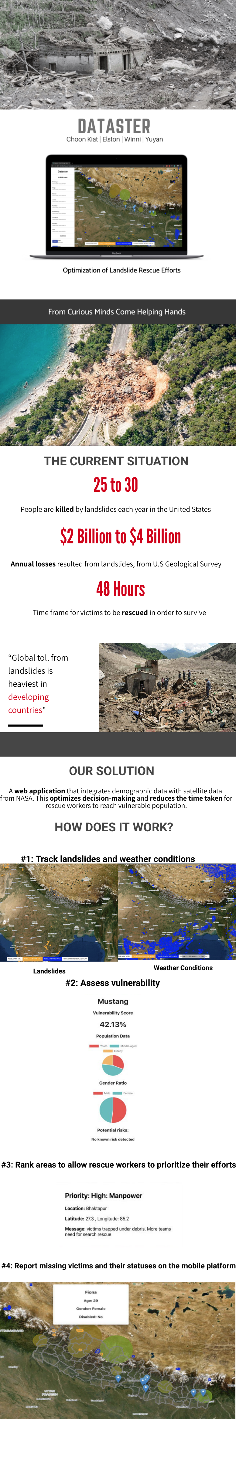
Optimization of Landslide Rescue Efforts
A platform that integrates satellite and population demographic data in Nepal to provide real-time information for rescue teams to deploy manpower effectively to most affected areas.
Background:
Landslides is known to cause billions of dollars in infrastructural damage and thousands of deaths every year around the world. Often, it is not known when and where a landslide will occur, resulting in unexpected loss of lives of people residing nearby and destruction of infrastructure. To add on to the difficulty, victims in collapsed buildings must be rescued in the first 24-48 hours after the event in order to survive. Our team chose this challenge because we believe that data can bring about powerful change to the world. With data, relief efforts can be optimised.
Since the 1950s, landslides in Nepal has killed over 1,300 people and destroyed 10,000 houses. Nepal, being one of the poorest and least developed countries in the world have inadequate resources and measures for landslide rescue efforts. This makes it difficult to reach out to the vulnerable population that are most at risk in the event of a landslide.
In our challenge, the groups of population that we define as vulnerable and most at risk are people residing in affected areas with little or no formal education, of old age, of low-income and people with disability. In the event of a landslide, communities can be the first responders due to the close proximity to the affected areas.
What it does:
In response to the current constraints and gaps in landslides rescue efforts in Nepal, our team came up with Dataster, a website that integrates satellite data(Landslide Nowcast & Precipitation) from NASA and population demographic in Nepal to identify the most affected area and prioritise rescue efforts. Rescue workers at the rescue site can also send "help messages" to the base to ask for more resources or manpower. In addition, locals in Nepal are able to contribute and crowdsource information on the whereabouts of their family members, neighbours and people who are vulnerable. This allows rescue workers to narrow their search for the lost.
Challenges Faced:
- Limited data in rural areas; as landslide tend to be localised, having access to more granular demographic data will help to identify the vulnerable population better.
Future plans
- Mobilising local communities for relief efforts they are the most familiar with the environment
- Integration with more data sources to predict risk of reoccurrences
- Incorporate early warning for landslide into the platform
Built with JavaScript and Firebase
Resources:
GitHub: https://github.com/elstonayx/dataster.git
Demo: dataster.herokuapp.com
Nepal landslide deaths highlight disaster risk reduction gaps. (2014, August 7). Retrieved October 19, 2019, from http://www.thenewhumanitarian.org/analysis/2014/08/07/nepal-landslide-deaths-highlight-disaster-risk-reduction-gaps
Landslides - Technical Hazard Sheet - Natural Disaster Profiles. (2012, April 13). Retrieved from October 19, 2019, http://www9.who.int/hac/techguidance/ems/landslides/en/
Landslide nowcast and precipitation. Retrieved from October 19, 2019, https://pmm.nasa.gov/precip-apps
Demographic data to assess social and economical vulnerability. Retrieved from October 19, 2019, https://nepalmap.org
Tags:
#disaster #data #dataster #landslides #Nepal #World #rescue #satellite #flood #aid #relief #tech #react #javascript #earth