
Earth Observers| From Curious Minds Come Helping Hands
Project Details
The Challenge | From Curious Minds Come Helping Hands
Preventing Disasters
Our project aims to create a public & cost free interactive platform to inform users about past and potential future natural disasters, focusing on earthquakes.
The challenge “From Curious Minds Come Helping Hands” provided our team with the opportunity to learn more about endangered areas of the world. After finding out that Indonesia has been struck from multiple physical disasters due to high seismic activity, we started toying with the idea of creating an interactive platform that could help Indonesian citizens and government members not only become more aware of the dangers of their country, but also alert them about earthquakes that may occur in the future.
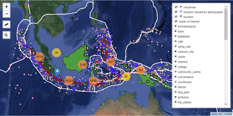
First of all, we had to collect the necessary data. Using multiple sources (cited below), we collected free files (in .shp form) containing a lot of different information about Indonesia. In more detail, places of interests such as the geographic positions of schools, hospitals etc, the center of earthquakes and the starting points of tsunamis that occurred in the past century and the geographic positions of Indonesian volcanoes. Using the public GIS platform QGIS, we edited all of the collected data and came up with the idea to calculate a “danger- free zone” in which public places can be safely build. In order to achieve that, we built buffer zones surroundings every earthquake center with a variety of radiuses, according to the magnitude of each one. Uniting said buffer zones, we created a zone that has most likely been highly affected from these types of hazards and is, as a result, an unsuitable zone for crowded public places, such as schools, hospitals, playgrounds etc. Therefore, the suitable zone is created because of the unsuitable one. However, it is important to note that the second zone isn’t absolutely safe from every physical disaster, but it is a lot less likely to be affected from them. In this way, an interactive map that contains all of this information was created thus completing the first part of our project.
Having gathered all this data, the second part of our project couldn’t be anything else than an attempt to predict the occurrence of physical disasters. We focused on earthquakes and tried to make predictions concerning our case study of Indonesia. We made use of Deep Learning Neural Networks (citation) and created a model that takes as input the time, longitude, latitude, depth and magnitude of previous earthquakes and forecasts about the future. The potential of this attempt is really great, as it can act as a probabilistic alerting system for the local authorities, given the fact that the forecasted points can be correlated with historical data and reveal the possible impact of a given earthquake for its surrounding locations. To make it more clear, given the fact that our model forecasts for an earthquake in Jambi, we can also take a look at historical earthquake data about Jambi and the impact they had on the local buildings, roads etc, and by this way create a complete alert system that acts as a helping hand for the local society. It is crucial to mention that this part combining the predictions with the historical effects data is not yet implemented, but it’s about to.
In summary, using only free data and platforms, we created a project that not only highlights Indonesia’s geo-physical vulnerabilities, but can also alert its users about future similar phenomena. It’s noteworthy that even though we focused only on Indonesia, our project does not have geographical limits, it can be applied to any place of planet Earth.
DataSources:
- https://pdfs.semanticscholar.org/4cb5/cbcdd65cd79167be1de01e1f7f7f378f9277.pdf?fbclid=IwAR1wLcj5H7Cdo943X2YA-nf3dV9mUDeBvz7V53X3klKiQo1JA0GxL7af5bA
- Atlas (used data from Landsat 2,3,4,5 and 7)
- National Tsunami Warning Center
- USGS (https://earthexplorer.usgs.gov/)
- NOAA (https://www.ngdc.noaa.gov/hazard/earthqk.shtml)
- Geofabrik (https://www.geofabrik.de/data/download.html)