
Hazard X | From Curious Minds Come Helping Hands
Project Details
The Challenge | From Curious Minds Come Helping Hands
Hazard X
Hazard X is a software soluation that aim to improve response to environmental hazards.
Problem Definition
Earthquakes events are becoming more frequent and more severe, leading to specific issues for affected communities. Earthquakes preparedness and improving our response to them can significantly mitigate loss of life and property damage. How can technology help communities improve their Earthquake prevention and response while ensuring access to shelters for medical attention in the aftermath of a natural disaster?
Value Proposition
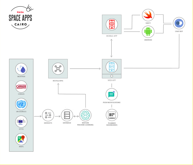
The idea approached the problem by proposing a two-part solution; one is a mobile app that helps disasters victims respond to earthquakes and another is a dashboard for authorities that can use existing datasets (such as which populations are most at risk) with real-time situational data to prioritize response.
Beyond real-time response, the app incentivized users to prepare long ahead of dire situations by using some instructions. Users create personalized evacuation plans in case their area is impacted by disasters.
On the other hand, we aim to create a machine learning which aims to predict disasters before they occur and support authorities with this conclusions for decision-making.
Idea Validation
Earthquakes prediction has been a challenging research area, where a future occurrence of the devastating catastrophe is predicted. We worked on three separate ML models that Which predicts a potential disaster and then alert authorities to get ready.
Earthquakes are one of the major catastrophe and their unpredictability causes even more destruction in terms of human life and financial losses. There has been a serious debate about the predictability of earthquakes with two concurrent point of views related to their prediction. One school of thought considers it impossible phenomenon to predict while other have spent their resources and efforts to achieve this task. In this work, sixty seismic features are computed through employing seismological concepts, such as Gutenberg-Richter law, seismic rate changes, foreshock frequency, seismic energy release, total recurrence time. Further, Maximum Relevance and Minimum Redundancy (mRMR) criteria is applied to extract the relevant features. A Support Vector Regressor (SVR) and Hybrid Neural Network (HNN) based classification system is built to obtain the earthquake predictions. HNN is a step wise combination of three different Neural Networks, supported by Enhanced Particle Swarm Optimization (EPSO), to offer weight optimization at each layer. The newly computed seismic features in combination with SVR-HNN prediction system is applied on Hindukush, Chile and Southern California regions. The obtained numerical results show improved prediction performance for all the considered regions, compared to previous prediction studies.
Methodology
The solution that we propose addresses the concerns from the survivor's perspective. Before the earthquake, we suggest a personal information about. With voice commands we incentivize potential survivors to find, and prepare a personalized escape route. This enables the survivor to more efficiently escape the disaster, and brings a feeling of being in control. During the training program, personalized needs and tags are opted in, that can provide personal insights and advice, and enables first responders to address the needs of the survivor
- The end user installs a custom mobile application or visits a web application accessible from their mobile device before a disaster.
- They can then configure their profile by going through a series of steps easily that builds a context around their unique situation and their location before disasters.
- With this profile data stored in a central location, local authorities can understand their particular needs and if they fit into a vulnerable community category. Relevant information can then be pushed to them.
- The end user can report any incidences or assaults via our app to reduce gender and youth issues.
When Earthquakes strikes, dispatchers can struggle to prioritize incidents, particularly when they are reported more than once across operators. Manual tracking of first responder teams can also take a dispatcher’s time away from manning calls. Big data visualization sits at the core of the solution, enabling the planner to take informed decisions during the disaster: integrated with personal disaster app, 3rd party datasets and having a direct link with governmental body budgets. Given the data collected from the survivors, available on the dashboard, the planner would be able to prioritize the teams to focus on the most vulnerable people, sending out notifications to the survivors.
- Local authorities and disaster management agencies build up a threat model about the community using a variety of datasets.
- The recommendations for prioritizing response is then plotted on a map.
- That information is then displayed in a dashboard (or pushed to incident responders).
Dataset and References
Earthquake prediction model using support vector regressor and hybrid neural networks