
Project Details
Awards & Nominations
Nomapp has received the following awards and nominations. Way to go!
The Challenge | From Curious Minds Come Helping Hands
NOMAD
NOMAD integrates NASA satellite data in a searchable format, so that climate refugees and nomads can find new homes.
ACTIVE WEB APP URL: www.nomapp.me
PROJECT REPO URL: https://github.com/Team-Nomapp/NOMAD
Background:
Project NOMAD was built to solve the challenges faced daily by hundreds of thousands of refugees and nomads. Political unrest, climate change, and food/water insecurity are among the existential dangers faced by these displaced persons. In fact, the UN estimates that by 2050, there will be over a billion climate refugees. Originally concepted to solve the "From Curious Minds Come Helping Hands" challenge by identifying vulnerable populations with NASA satellite data, we expanded the scope of our solution to not just identify vulnerable populations, but also to empower them to find, move, and settle in new lands when faced with insurmountable challenges at home.
What it does:
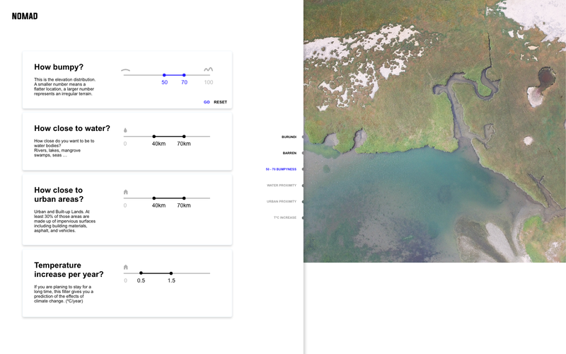
Project NOMAD is a web-based platform that integrates satellite data on land classification, elevation, estimated climate through 2100, and the position of fresh water and urban areas, in a searchable and user-friendly environment. The country of Burundi was selected initially as political unrest has resulted in over 340,000 internally displaced persons, according to UN estimates. Raster pixel data from each of the chosen data sources is processed into points, and from these points, easy-to-understand measures of ‘habitability’ are calculated (average slope, distance to fresh water, distance to urban areas, distance to arable land, and estimated temperature increase by 2100). The user can select their desired values for each of these ‘habitability’ measures, and the web platform quickly searches through millions of data points to provide the user with locations that match their chosen values, within their country. The data is pre-processed into spatial trees to vastly reduce the search time for points that match the user's criteria, and to enable scalability to large countries/areas that contain upwards of a billion points, with little performance drop†. After selecting a location, the user is presented with the raw satellite data collected from that location, superimposed against an interactive map. The user interface allows them to browse the other locations that match their desired measures by using land classification as a filter (ex. Forest, Crop Land, Herbaceous Grassland).
Resources:
Project NOMAD uses resources collected from the USGS's and NASA's LP DAAC portal, and NASA's NEX website. More specifically, Land Classification, Digital Elevation, and Water Body Classification data were selected from LP DAAC (from the MODIS and ASTER missions), while Global Warming Temperature Predictions (Global Daily Downscaled Projections) were collected from the NEX portal. A shape file of the country of interest, Burundi, was downloaded from a third-party website, and this was used with NASA's AppEEARS tool to download all LP DAAC data contained within the borders of Burundi as a single set of GeoTIFF files.
Future Plans:
Moving forwards, we plan to integrate further data sources that users may search through and filter by. More specifically, we will integrate socioeconomic measures such as housing prices, incidence of tropical disease, and average daily temperature/precipitation. Furthermore, as the branch and bound search architecture allows for efficient search of millions of points, we plan to eventually allow users to select any country on earth to settle in. Lastly, we plan to offer a simplified version of the platform over analog SMS to increase accessibility in developing nations with inconsistent web access.
Built With:
Python, Falcon, Node JS, React JS, Mapbox API, Deck GL, Ant Design, Adobe XD, PostgreSQL, Zeit Now
Try it Out:
More info available at: https://github.com/Team-Nomapp/NOMAD
Web App hosted at: www.nomapp.me
Tags:
Refugees, Nomads, Climate Change, Impact, Search, Spatial Tree, Branch and Bound, Remote Sensing, ASTER, MODIS, Elevation, Land Classification, Geospatial, GIS, Data, AppEEARS, LP DAAC, Python, Web, Web App