
Project Details
The Challenge | From Curious Minds Come Helping Hands
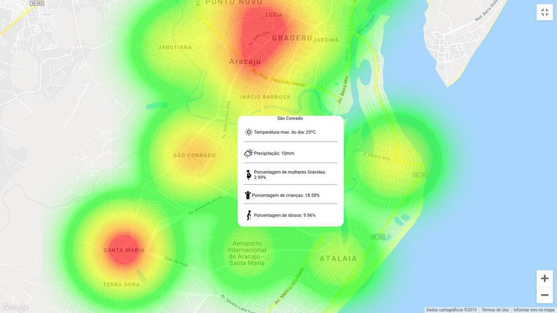
Mosquito Watcher
Mosquito Watcher is a tool for viewing most vulnerable populations to mosquito-borne diseases in Brazil
Mosquito-borne diseases are a serious concern for Brazilian Public Health System. They include viral diseases like Dengue, Zika and Chikungunya. In 2016, it is estimated that these infections caused a loss of R$ 2,3 billion to Brazil's economy [1]. This year, more than 1,4 million cases of Dengue have been recorded in Brazil [2]. Among affected individuals, serious forms of these diseases are more likely to occur in children, elderly and pregnant women [3, 4]. Mosquito proliferation and its associated diseases are depedent on climate and weather conditions [5].
We propose a map visualization tool to assist Primary Health Care teams to better plan mosquito control efforts. By combining weather data, a mosquito proliferation model and demographic information from Brazilian Census and Health System, we can pinpoint regions for health teams where the more vulnerable population of children, elderly and pregnant women can be affected.
We have developed a prototype for this service which uses satellite data for temperature and precipitation from Nasa's AIRS (Atmospheric InfraRed Sounder), Version 6, Level 3 [6], a simple model of mosquito proliferation [5], and data from Brazilian census [8]. Prototype code is available at GitHub [9] and was developed using Django framework, React and Google Maps API.
Future work can improve the predictive model by including other satellite data. Also, we should allow for primary health care workers to record their own local data and track the benefits of using the system.
#satellite, #brazil, #aedes, #primary health care, #mosquito-borne diseases, #django