
Apollo 11| Rise to Resilience!
Project Details
Awards & Nominations
Apollo 11 has received the following awards and nominations. Way to go!
The Challenge | Rise to Resilience!
Greenification
A platform composed by two linked app that provide a way to obtain and manage data by professionals using NASA EOS data and Machine Learning and help users find the right plants in order to prevent wheather extreme conditions using Augmented Reality.
The aim of this project is to create an ecosystem composed of two apps and a centralised server with the objective to let the public and private sectors work together to help the environment.
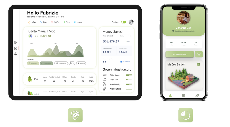
The idea is to give the public part of the equation, the "Greengineer", an app named “Sprout” (you can see a prototype of the app here: https://gitlab.com/SalvatoreCapuozzo/NasaAppML ) that interlaces data from Nasa Earth Observing System (specifically satellites like Aqua, Terra and all the A-Train constellation) with data harvested in situ using Machine Learning video analysis and an Arduino with an array of sensors (you can fins part of the research material here: https://www.dropbox.com/sh/1osyfogmd6whevz/AAC_ZhvCzhguBmEfyXCMZJJaa?dl=0 ).
The data from the satellites and sensors could give the operator a comprehensive scientific visual of the situation of the environment (you can see a first batch of the data used here: https://gitlab.com/antonioelefante10/dataformatter ) and the Machine Learning will help him with the evaluation of the factual problems in the place he is located, and via the usage of a brand new ratio formulated ad hoc called GBG Index (Gray-Blue-Green) establish employment and effectiveness of Green Infrastructures and nature-based solutions on selected areas with an accurate prediction of the improvable zones.
All this data give a perfect representation of the environmental risks, and the app itself will suggest how to countercharge climate change, soil erosion, flood or drought, leveraging the AI built in the server. The Greengineer will obtain a design for better green-infrastructure solutions based on current and historical data.
The data mixed will result in a comprehensive visualisation given by
- NASA satellite data from the EOS
- Machine Learning from the app
- Sensor data form the array of sensors embedded in the Arduino
- Localizaion data
- Weather forecast and long term previsions
The server will mix the harvested data with the outcomes of the decisions of the Greengineer to display the best suggestion possible to public users in a dedicated app: “Blossom” (you can see a prototype of the app here: https://gitlab.com/SalvatoreCapuozzo/NasaAppAR ). Using this app and a specific display of Augmented Reality, users can see the way their property and the ones converted by the Greengineer will results after the Grey-to-Green transfomation. The app (you can find the sketches and projects here: https://www.dropbox.com/sh/ubzwrjx5p7b3lzr/AACALvXU1cYXtrQyLwHrY36ia?dl=0 ) will suggest the right type of plants to sow to mitigate the weather problems, like the urban island heat effect or the local drought, soil erosion and flood prevention. Increasing the air quality and ground water retention would dramatically change the way we live in our cities and our rural areas.
The app also displays instructions on how to plant and grow that specific type of culture and the impact it would have on wildlife. We can even leverage the social part that a so visual app can bring to the table and create a competition on social network using a simple gamification architecture in order to push more and more people on the platform and have them engaged saving the planet.
The User ap will serve as
- Helping the user on which plant seed
- How to plant them
- What they can obtain changing the landscape
After the variations on the landscape is certified by the Greengineer, discounts on property taxes imposed by the government or insurance agencies, could be applied. We also thought about the possibility to export a 3D model of the assessed greenspace in order to 3d print it for public display and preliminary technical training (you can find the 3d models used in the app here: https://www.dropbox.com/sh/be1oih2a10ztp54/AAAEnm3ny7Phnex01dEi0goSa?dl=0 and the first 3d print from the app here: https://www.dropbox.com/sh/9o8dij4nefs5978/AACgaxUhsQEIARAQmH4Yhr6wa?dl=0 ).
You can find some photos of our works here: https://www.dropbox.com/sh/7yn2oav61ug7tfg/AABuGAs...
And our keynote of the presentation here: https://www.icloud.com/keynote/04QD5UqADBTdUB3UQ39bbjn8w#Nasa_Space_Apps_Challenge_2019
or here: https://www.dropbox.com/s/qsxxnjp40n10oxk/Nasa S...
We can save the planet together, the public and private, the engineers and the users, just by embracing the greenification
The future has never been so Green!
Sources:
NASA earth data: https://search.earthdata.nasa.gov/search
A-Train constellation: A-train (satellite constellation) - Wikipedia
Landsat data: https://landsat.gsfc.nasa.gov
NASA EOS: Earth Observing System - Wikipedia
Ecostress index: https://ecostress.jpl.nasa.gov
Objectives of the project: Sustainable Development Goals - Wikipedia
Sendai framework: https://www.unisdr.org/files/43291_sendaiframework...
Aqua satellite: Aqua (satellite) - Wikipedia
SMAP data: https://smap.jpl.nasa.gov
GRACE Index: https://grace.jpl.nasa.gov/data/get-data/monthly-m...
Aura satellite: Aura (satellite) - Wikipedia
MODIS data: https://terra.nasa.gov/about/terra-instruments/mod...