
Blind Men and the Elephant| Set Your Sights High!
Project Details
The Challenge | Set Your Sights High!
NASA builds and operates numerous satellite and airborne missions that deliver critical measurements and data to the world’s science community. Your challenge is to develop a tool that enables people to identify NASA satellites and satellite instruments as they fly over their locations on Earth. Help people explore the data and applications coming from the instruments overhead!
Blind Men and the Elephant
A satellite is like one blind man feeling the elephant. We gather many blind men to feel the elephant at roughly the same time.
Blind Men and the Elephant
Background
Earth Scientists and Engineers often turn to one data set to answer questions about a geographical region of interest.
Our team asked the question: What kinds of data can the satellites above provide us.
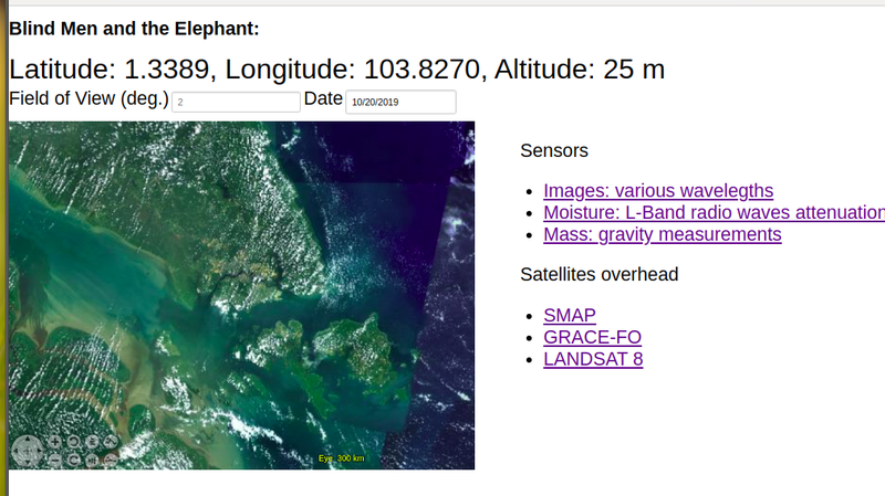
Website prototype
We build a web application using NASA WorldWind javascript API.
This allows a user to select a point on the 3D globe. Our tool then answers the question: What satellites are above us? What data categories does each satellite provide. And a link to download the data.
Blind Men and the Elephant website
Resources used
- Satellite position data source: Two Line Elements (TLE) via api.nasa.gov
- Satellite position calculator: https://github.com/Bill-Gray/sat_code
- Satellite visibility calculator: https://github.com/siuyin/bmele by Earl Chow
- "Interesting" Satellite database: Curated by Mateusz Kostrzewa and Yuen Kit Siew, https://www.n2yo.com/api/, https://landsat.gsfc.nasa.gov/,
- Web app: https://github.com/siuyin/bmele , implemented in Go and NASA WorldWind by Loh Siu Yin