
Moto Galáctica| Set Your Sights High!
Project Details
The Challenge | Set Your Sights High!
OMe
What things can I see looking at the sky right now
The Challenge
We’re “Moto Galáctica”. In this challenge, we think about developing a solution so that the great curious of the aerospace can identify what is happening above them.
No matter the age or knowledge, we just want them to see the sky and everything that is going on there.
Introduction
How many times a day do we look at the sky?
How many times do we ask ourselves what is beyond our sight?
We invite you to know that we are seeing far away ... If you see it!
Background
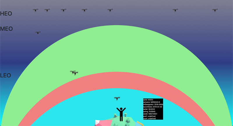
Our team created OMe. OMe is an application to discover objects that are in different orbits (Leo, Meo, Heo), but within a range determined by the user.
We show that information sensually on any device. You just need to know your positioning and OMe will do the rest.
This interface can obtain and answer calls from other interfaces. But the information will always depend on the objects that have information about their height, speed and coordinates.
In the beginning it was thought for satellites and planets. Today we believe it can be used for any device that provides us with a Rest API the information.
We also think about putting together a personalized set-up so OMe informs space lovers that they have a telescope to let them know when the object they want to see will be close.
We hope to expand the audience and involve people of all ages to interact and learn from the different objects that surround us.
Image
Our Solution
We have designed OMe for Web and Mobile App with the following capacities:
- Access to anyone.
- Code available for the use the EndPoint and the interfaces.
- Know the objects that surround us. If it is a satellite to learn if it is geostationary or not. When it was launched and from where.
- Discover space in a different way..
Next Steps
- Improve data visualization.
- Spread widgets with dynamic background.
- Create dynamic screen backgrounds.
- Add aircraft tracking.
- Add positioning of planets.
Resourses
- PHP 7.2
- Lumen
- JavaScript
- HTML5, CSS
- MySQL
- DATASET: https://www.n2yo.com/api/ and https://opensky-network.org/apidoc/