
Project Details
Awards & Nominations
MonitOil has received the following awards and nominations. Way to go!
The Challenge | Show the World the Data!
MonitOil
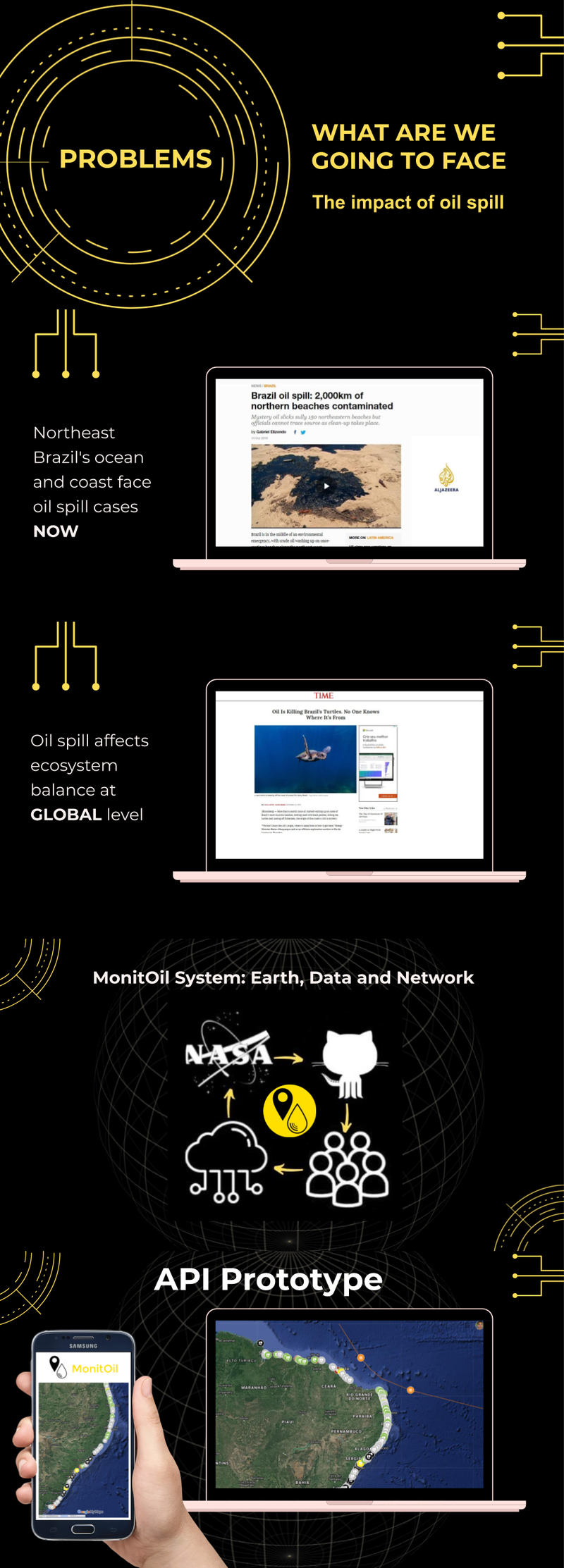
International collaborative mapping for monitoring oil spill environmental emergencies. Our goal is to generate a platform for crosschecking information from scientists, governments, citizens and journalists.
- What can we do
MonitOil is a crowdsourcing map project to monitor oil spills around the world. We use NASA technologies to verify data from scientists, journalists, governments and citizens.
The oil industry is the most polluting in the world! Our monitoring does not solve the problem but reduces risk and helps manage damage based on World Wind and World View data and NASA Crisis Mapping Toolkit methodology. Our flexible methodology enables GitHub to interact with groups by monitoring a local-regional scale on open data.
- How can we do
We don't want new filter spills, but if you reproduce it, you're ready to act effectively!
The data are crossed by researchers. Just as you need a periodic table for a chemical study, so you need a virtual globe for geographic responses.
Our project is networked, adaptable, open! The world already has NASA support for several other data display possibilities. This is one more of them!
Comments in popular mode is another big advantage! World View enables us to do that! The language is accessible and can be replicated for students and professionals.
- Why can we do
We need more people in this! That's why we believe that hackaton is just the beginning of open data development, collectively, to understand the problem and address based on cartographic communication.
With open source, databases and networks, we can develop the world's first monitoring and cross data with NASA! A combination of ambition, opportunity and need to use NASA data to credit this project. Because NASA has a larger collection of memories of the planet Earth!
We wish more Developers and Designers (Java) to join our international team currently formed of professionals in Communication, International Relations, Human Rights, Environmental Management and Industrial Automation.
- Where can we start doing
We want to help not forget environmental crimes based on techniques, science and information. That way, around the world, the way you can control can monitor or only one place on earth can see NOW!
We can simplify how to respond to complex oil spill crisis situations! We can know WHERE, WHEN and HOW to act in emergencies like this! We are living as a result of a spill in Northeast Brazil and we need the help of NASA and brazilians agents! We want to preserve a LIFE on land and at sea! Here and now!
- References Links
https://github.com/NASAWorldWind
https://github.com/nasa/CrisisMappingToolkit
https://worldview.earthdata.nasa.gov/
https://www.nasa.gov/topics/earth/features/oilspil
https://github.com/antoniohclaranjeira/MonitOil
https://www.bbc.com/portuguese/brasil-49991795
- Prototype of API visualization with data architecture in XML. format