
Project Details
The Challenge | Show the World the Data!
Globe Trotter
A Visualisation of space telemetries
Project Globe Trotter
Our Team decided to work on "Show the world the data challenge" in this edition of NASA Space Apps
Our Main Goal is to design an application for helping analysing data that is publicly available but is difficult to analyse and decipher in a short period of time. The open source API's response JSON is only machine readable and can be tiresome to analyse for Students , Teachers, UG Students , Scientists and Educators etc.
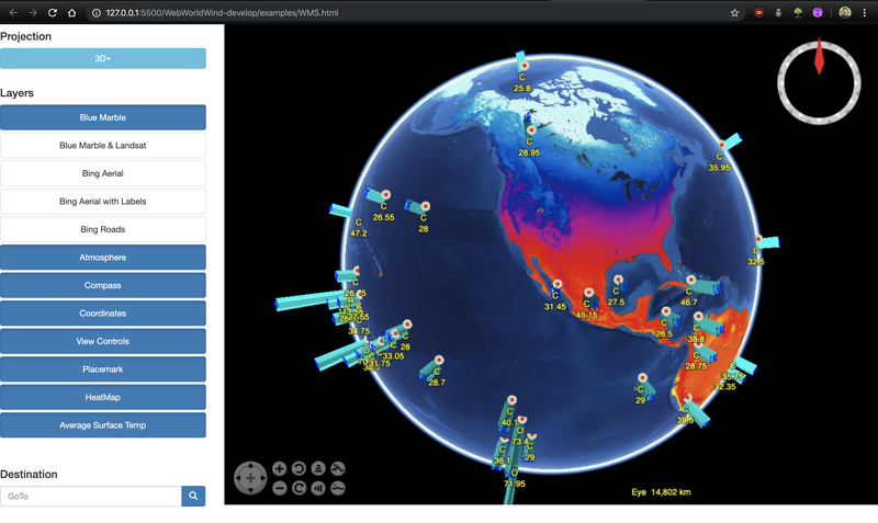
The Application utilises NASA Open(open source) API's, World Wind to combine a virtual 3D globe with respective satellite data fetched from NASA's APIs.
We Developed an interactive UI website for efficient and easy analysis of API Data . The website uses the world winds framework to simulate the earth Model.
The data pertaining to various locations is extracted from API's available. Then it was linked to the World wind Framework to display accurate information for various locations around the globe. The web app implements a login system which keeps track of various API keys requested per user and serving the individual hence maintaining data reliability.
This app can be used in various scenarios where fast and reliable data collection is crucial and can make a significant difference in the outcome of these scenarios. Imagine Scientists receiving space telemetries at the tip of their fingers. Students would be able to make more detailed reports than ever before using this tool. Disaster Management teams can keep a track of large scale natural disasters and thus provide better destruction aversion. Geologist can easily study real-time changes on the surface of earth.
Right now, due to paucity of time and limited resources we were only able to properly use DONKI(Database of notifications knowledge information) to build an earth relevant web app(1 of the 17 Open NASA APIs available).
Future Prospects:
- We plan to build this application to include more of the earth related APIs which include some near real time API's.
- Another thing we originally planned was to make a 3D realtime satellite tracking system using already available 2D tracking data.
- With API's providing data on other Celestial Objects like our Moon, Mars, The Sun etc we plan to develop a similar web apps for our solar system brethrens.