
Project Details
Awards & Nominations
Massa has received the following awards and nominations. Way to go!
 Galactic Impact

The Challenge | Smash your SDGs!
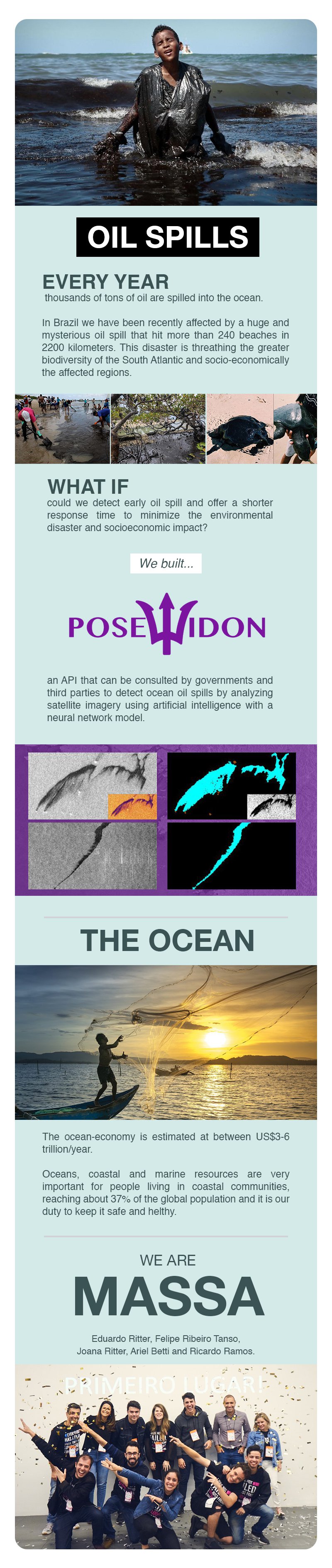
Poseidon
API to detect oil spill leak through SAR images using AI and Neural Network.
CHALLENGE ACCEPTED
We chosen the Smash Your SDG Challenge and worked with the SDG 14 (Life below water), specific SDG 14.2, 14.5, 14.7 and 14.a.
THE BIGGEST MOTIVATOR
Our biggest motivator to have chosen this challenge and built the Poseidon was the current situation of the environmental disaster that hits our country (Brazil) with the huge and mysterious oil spill that has already reached more than 240 beachs in 2200 km of affected Brazilian coast. It is estimated that over 4,000 tons of oil has already been removed from the beaches. This disaster is threathing the greater biodiversity of the South Atlantic and socio-economically the affected regions and it is estimated that it will not recover itself even in a 100 years. How could we have helped to minimize the environmental and socio-economic impact this would cause?
The ocean-economy is estimated at between US$3-6 trillion/year. Oceans, coastal and marine resources are very important for people living in coastal communities, reaching about 37% of the global population and it is our duty to keep it safe and helthy.
OUR SOLUTION
Poseidon is an API that can be consulted by governments and third parties to detect ocean oil spills by analyzing satellite imagery using artificial intelligence and deep learning model. Identifying oil spill early can offer shortest response time and more agile measures can be taken to minimize the environmental disaster and socioeconomic impact.
Our first problem was treating images. We need to understand that each pixel in a satellite image has one more frequency, infrared, in addition to RGB. We also need to understand that in reality a pixel is a multidimensional matrix and we start with these gaps to teach our neural network. We decided to work on that.
Another problems was related to biolumine plankton that look very much like oil spots seen from aero images and it was exactly this infrared satellite that helped us teach our network. When we use specific filters, we can separate plankton oil stains using the infrared itself.
Our second problem was separating oil stains from clouds and teaching our neural network, when she understands image replications (shadow) she should be able to distinguish from oil stains.
Now, as our pre-treatment and network set up, we needed processing mainly. We use google codelab to be able to train and test our network.
The most difficult part was to find a dataset of previous events of oil spill that could improve our training neural network model and we kindly have access through Marios Krestenitis researchs [1]. We had access to Open Hub Access from Copernicus Sentinel-1 images and found some images in NOAA Imagery (photo library) and used to compare the registred events of oil spill through satellites images and used to train our neural network.
Our neural network is capable to analyze a lot of images searching for oil spill point. This API can be used by third part applications or governments systems to improve the gain of time response to an environmental disaster.
We would like to improve our API and AI and create a robust tool to help not only Brazilian government but all others governments. We would like to build some features like:
- Time prediction of oil spill dissipation through sea currents.
- Identify potential oil spill responders through positioning analysis and oil tanker routes.
TOOLS
Languages: Python, React, Node
Libs: numpy, rasterio, cv2, tensorFlow, keras, scipy, skimage, pandas, imageai, flask, matplotlib
Dev tools: Visual Studio, CodeLab e Jupyter Lab
Neural Network: ResNet
WHAT ABOUT SOME FACTS?
- Nearly 2.4 billion people (about 40 per cent of the world’s population) live within 100 km (60 miles)of the coast.
- Oceans, coastal and marine resources are very important for people living in coastal communities,who represent 37 per cent of the global population in 2017.
- Fish is one of the most important sources of animal protein. It accounts for about 17 per cent ofprotein at the global level and exceeds 50 per cent in many least-developed countries.
- The nutrients found in fish are important for optimal neurodevelopment in children and for improvingcardiovascular health.
- About 97 per cent of the world’s fishermen live in developing countries and fishing is their majorsource for food and income. Women account for most of the workers in secondary marine-relatedactivities such as fish processing and marketing.
- The ocean-economy, which includes employment, ecosystem services provided by the ocean, andcultural services, is estimated at between US$3-6 trillion/year.
- Fisheries and aquaculture contribute $US100 billion per year and about 260 million jobs to the globaleconomy.
- Shipping is responsible for more than 90 per cent of the trade between countries. The global oceansbased economy is estimated at $US3 trillion a year, which is around 5 per cent of global GDP.
- Approximately 50 per cent of all international tourists travel to coastal areas. In some developingcountries, notably Small Island Development States, tourism accounts for over 25 per cent of GDP.
REFERENCES
- Krestenitis, M., Orfanidis, G., Ioannidis, K., Avgerinakis, K., Vrochidis, S., & Kompatsiaris, I. (2019). Oil Spill Identification from Satellite Images Using Deep Neural Networks. Remote Sensing, 11(15), 1762. 2.
- Krestenitis, M., Orfanidis, G., Ioannidis, K., Avgerinakis, K., Vrochidis, S., & Kompatsiaris, I. (2019, January). Early Identification of Oil Spills in Satellite Images Using Deep CNNs. In International conference on Multimedia Modeling (pp. 424-435). Springer, Cham.
- Marios Krestenitis, Research Assistant from CERTH/ITI as consultant
- European Maritime Safety Agency (EMSA) (finding oil spill events) <http://www.emsa.europa.eu>
- Open Access Hub from Copernicus Sentinel-1 data <https://scihub.copernicus.eu/dhus/>
- NOAA Photo Library <https://www.photolib.noaa.gov/>
- NOAA Oceans & Coasts <https://www.noaa.gov/oceans-coasts>
- The Guardian - "Brazilians rally to clean beaches amid outrage at Bolsonaro's oil spill inaction" <https://www.theguardian.com/world/2019/oct/22/brazil-oil-spill-beaches-bolsonaro-volunteers>
- Telegraph - "Brazil deploys 5,000 troops as fury mounts at inaction over worst oil spill in country's history" <https://www.telegraph.co.uk/news/2019/10/23/brazil-deploys-5000-troops-fury-mounts-inaction-worst-oil-spill/>
- Earth and Space Science - "Brazil’s Oil Spill Is a Mystery, so Scientists Try Oil Forensics" <https://eos.org/articles/brazils-oil-spill-is-a-mystery-so-scientists-try-oil-forensics>
- BBC - "Brazil environment: Vast oil spill hits dozens of beaches" <https://www.bbc.com/news/world-latin-america-49837355>
- CNN - "Mysterious Brazilian oil spill could be 'criminal,' Bolsonaro says" <https://edition.cnn.com/2019/10/09/americas/brazil-oil-spill-intl/index.html>
- The New York Times - "Mysterious Oil Spill Becomes New Environmental Crisis for Brazil" <https://www.nytimes.com/2019/10/08/world/americas/brazil-oil-spill-beaches.html>
- Aljazeera - "Brazil oil spill: 2,000km of northern beaches contaminated" <https://www.aljazeera.com/news/2019/10/brazil-oil-spill-2-000km-northern-beaches-contaminated-191014105724674.html>
- CBS News - "Brazilians come together to clean beaches after massive oil spill decimates coast" <https://www.cbsnews.com/news/brazilians-come-together-to-clean-beaches-after-massive-oil-spill/>
- Percentage of Total Population Living in Coastal Areas <https://sedac.ciesin.columbia.edu/es/papers/Coastal_Zone_Pop_Method.pdf>
- Factcheet> People and Oceans <https://www.un.org/sustainabledevelopment/wp-content/uploads/2017/05/Ocean-fact-sheet-package.pdf>
- Oil Tanker Spills Statistics 2016 <http://www.itopf.org/fileadmin/data/Photos/Publications/Oil_Spill_Stats_2016_low.pdf>
- How far does the territory of Brazil go outside the continent? <https://super.abril.com.br/mundo-estranho/ate-onde-vai-o-territorio-do-brasil-fora-do-continente/>
TAGS
#satellite #deeplearning #ia #ai #neuralnetworks #oil #oilspill #disater #environmentdisaster #spaceapps #spaceappsbr #spaceappssp #massa #SAR
WE ARE TEAM "MASSA"
Ariel Betti: Full-Stack developer at a fintech startup and studying Internet Systems at FATEC.
Eduardo Ritter: Chatbot Specialist. Graduated in Database and studying MBA in Data Science.
Felipe Ribeiro Tanso: Graduated in Game Design. Studying Big Data, Machine Learning and Data Mining. Inbound Marketing Specialist.
Joana Ritter: UX Designer Chatbot Specialist. Graduated in Pedagogy, MBA in Design Thinking and Studying Postgraduate in Information Architecture and Usability.
Ricardo Ramos: Data Scientist and Machine Learning engineer. Studying Systems Analysis and Development and MBA in Data Science.