
Citizens of the Earth🗺️| Spot That Fire V2.0
Project Details
The Challenge | Spot That Fire V2.0
FIRECHARM
We collect the data from social media platforms by analyzing the posts to prevent and to warn about possible fires. We also obtain information from NASA’s satellites to evaluate globally fire prone areas.
1. MOTIVATION
Each year, around $11 billion of property is lost at an average. Recently 640 million acres was affected in the amazon rainforest due to fires. This not only affects the habitation but also degrades the ecological balance. It opens up forests to invasive species, threaten biological diversity, alter water cycles and soil fertility, and endanger the people who live in and around them. 400 million hectares of vegetation around the world are destroyed or degraded by fire.
2. OBJECTIVE
NASA Space Apps Challenge shows us how NASA has strived to reduce the time of early detection of fires using satellite information. We have come up with a way how the general public and local authorities have come up with a way to prevent this.
Our mission consists in detecting fires as soon as possible and letting people join us in preventing the fire.
To achieve this, we are using NASA’s FIRMS and social media platform so that such situations can be handled in real time. The local authorities will be informed directly through the satellite and in addition we have built an app for the local residents who can alert their friends, family and the respected authorities in one click. Through this, we engage and encourage people to use this prevention mechanism in creating global fire awareness.
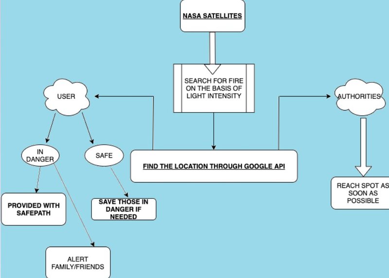
3. DESCRIPTION
Uml diagramatic representation
Data Sources
We collect the data from social media platforms by analyzing the posts to prevent and to warn about possible fires. We also obtain information from NASA’s satellites to evaluate globally fire prone areas.
Data Processing
- We implemented a model based on real time satellite images to categorize the risk level at a global level.
- We analyze texts and images coming from social networks, tools and local volunteer collaborators through our mobile application.
- Data such as population density, forest density are collected.
- The received images are readily checked through machine learning algorithms and image processing (using Open CV) for accuracy.
Cross Check Model
A model based on Machine Learning combines the present generated data and the previously processed data, decides whether to issue an alert. This model is trained through various datasets to prevent erroneous output.
Alerts Promulgation
In the event of a fire alert validated by the model and an authority, it will be communicated:
- To the global alert system corresponding to the specified affected area.
- Through SMS to telephone users close to the area through the following channels local ISPs, as long as they offer their collaboration.
- To users of the mobile application in the affected area
- To those users having personal assistants such as Google Assistant, Alexa, Siri, Cortana, etc
4. About the APP
We invite citizens to participate in early detection through an app that allows:
- Have information about active fires in your area.
- SOS signal sent to local authorities when you are in danger zone.
- Shows list of friends who too are in danger zone.
- Obtain safe routes away from the fire.
- Map keeps rerouting until user reaches a safe location.
5. Source code
The source codes are stored in a Github account. It contains source code for the Android application, graphic files, documents and prototypes. The codes are under MIT license and could be used for any purpose.
The link is provided below – https://github.com/Srijan307/Fire_spot.git
6. Web Data Extraction
An extractor/ scraper refers to an automatic web data extraction tool that extracts data from the web, which not only include social networking sites, such as Facebook, Twitter, Instagram etc., but also include blogs, wikis, and news sites.
Tools namely Brandwatch Consumer Research and Hootsuite Insights can be used for this purpose.
7. Conclusion:
The project has a high chance of becoming a successful reality as the technology being used here is already successfully used in similar fields. This project is just the use of the same tech. in a slightly different field.
This project will be of immense help to better the health of the Earth as we would be able to control fires when they will be just in their early and small stages. Earlier control on fires will mean cost reduction in damages. This money can be used in various other important fields like healthcare, education and also the development of FIRECHARMS.
This project will also help people to know about various types of fires and there prevention and safety measures in each case thus creating more awareness among the masses.
In future, this app can also help save a damage of life from not only fires, but also disasters like Volcanic eruptions etc.
This project has helped us to know a lot more about the problem in detail and has helped us contribute to the betterment of the Earth.
To bring this project to light, a crowd funding process can be carried out and people can be brought in from all around the world by crowd sourcing
8. The Team
Subham Dutta – https://www.linkedin.com/in/subham-dutta-4097b1190...
Sagar Khanna - https://www.linkedin.com/in/srijan-gupta-2756a118b...
Soumyadeep Bohidar - https://www.linkedin.com/in/soumyadeep-bohidar-10b...
Srijan Gupta - https://www.linkedin.com/in/srijan-gupta-2756a118b...
Saurav Kumar - https://www.linkedin.com/in/srijan-gupta-2756a118b...