
Data Forest| Spot That Fire V2.0
Project Details
The Challenge | Spot That Fire V2.0
IoTree
seeding data
The Amazon forest wildfires in 2019 had a major social and economic impact, especially for those who survive through this ecosystem. They were the subject of many discussions around the world due to the forest great importance for the maintenance of life on the planet. That’s what moved us to create our project.
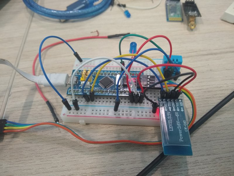
In order to monitor in real time variables that are not quickly measured by satellites, IoTree has been created. More than being monitors, we aim to be a data forest. We intend to install in selected trees an electronic device capable of detecting sudden changes in temperature, as well as being aware of any smoke present in the atmosphere, precisely showing places of focus in the formation of burns and transmitting the collected data to a global satellite network.
Several devices will be installed on trees in golden proportion, communicating with each other through an ad hoc network of master-elect, and only these will be responsible - that is, a tree can act as master of other n slave trees, simplifying the path for obtaining data - for communicating between the satellite and the forest. We ensure that all devices are functioning through internal and external intermittent checks: on each IoTree an internal component check will occur and if everything is working properly, it returns this response to its master, who in turn will communicate with the global network.
All devices run at reduced activity, consuming less energy, until one of the sensors catches an anomaly. So there is no need for everything to be working 100% all the time. Through selection algorithms, we can choose which devices will operate at reduced activity and which devices can be in standby mode to save maximum energy. The best way to deduce which areas deserve more attention is by analyzing variables that influence the onset of fires, such as warmer weather, reduced air humidity, and others. Likewise, even in regions where these variables are more likely to start a burn, there are areas that in recent years have suffered the highest incidence of this disaster, in these regions the attention should be greater, so we guarantee that our resources will be allocated to the most relevant areas.
We use the Fibonacci sequence to locate outbreaks of fire, providing greater resources the smaller the area in which this disaster occurs. We are then able to sustain a network that communicates by means of low frequency radio waves, having in each of these devices smoke detectors, thermoelectric meters, accelerometers, all collecting data that will later be sent to our microcontroller board. For IoTree to have power, we use photovoltaic plates, positioned at the top of the structure, always facing the sun.
This network will be able to monitor fires in real time, enabling us to work later on deforestation and even flooding (such as where the forest acts as a natural barrier to overflow).
In case of a wildfire, we will send a signal to the satellite that will take this information to nearby communities, SMSing all DDD cell phones in the affected area, informing them quickly about the incident and allowing an early reaction from the community ahead to the threat.
In addition to using global satellites for the external communication of our data forest, we can cross-check information provided by them, such as the direction and velocity of the air currents on site, allowing future prediction of locations that could be affected if the responsible authorities do not mobilize.
This project was made possible only by the Space Apps Challenge event that allowed us to take a fresh look at innovation in solving core issues for the preservation of life on Earth. During the idea design process, we had the help of several mentors mediated by the local organization of the event who were incisive to ask us all the time how much our idea could still improve. We had the constant encouragement of Quickup, the startup we represent and are proud to be part of the magnificent team, which provided us with broad, interdisciplinary and innovative insight. In addition to the support of the labs ICON, Onda Digital and Jeferson Lima, which provided resources for us to prototype and test the functionality of the idea.
Going forward, we expect to increasingly correlate data obtained through the data forest with data captured by NASA satellites, giving greater assertiveness to the projection of potential disasters and potentially affected communities, allowing the use of this data in network training, that will be able to point more and more precisely where the next place to burn can be, providing relevant data to the responsible authorities near the regions, warning not to remedy.
https://gitlab.com/vinimlo/nasa
tree, wildfire, deforestation, technology, forest, data