
ESTIA| Spot That Fire V2.0
Project Details
Awards & Nominations
ESTIA has received the following awards and nominations. Way to go!
The Challenge | Spot That Fire V2.0
ESTIA
The project has the purpose of creating an Android and a web application that enables each and every citizen to spot and report any potential life threatening fire incident to official departments.
Research Team
- Karampelas Georgios
- Kontogiannis Orestis
- Koumantos Orestis
- Pseimadas Pavlos
The whole idea
There is a plethora of possible expansions to this project, such as the use of thermal cameras and drones that will upgrade the system. Those will be placed in areas with high risk and they will create a highly functional network that will respond rapidly to validate the problem. On the other hand, those new technologies have a mid-ranged cost for their purchase, their installation and also for their maintenance.
Furthermore, for the smooth functioning of the system the communication and the synergy of the local authorities is of utmost importance as well as the necessary training on the interoperability of the drones and thermal cameras.
The cameras are designed to be installed in high altitude antennas in specific locations in forests or open areas according to their specs. The pre-set temperature difference that they will be set to detect will have considered parameters such as thermal signals from humans or animals in the area, the ground’s temperature fluctuation during each season and other area specific parameters. In that way, we will avoid false signals from sources that are not incident related. In areas that thermal imaging from cameras is limited or worsened due to inaccessibility and bad line of sight we have designed a solar charged, drone-based station network that will cover the need of imaging and accurately locating the area of interest. Drones will be able to patrolling high-risk areas equipped with thermal cameras. Of course, there are a lot to consider regarding the proper mechanical assembly of the drones, like size, gyroscopes, batteries capacity and flight duration, range and weight.
Once the fire is detected the control panel will automatically receive a notification, so that local authorities will be immediately informed about the threat’s location and assess the situation. In case of an imminent threat the application will notify the users which are located currently in a nearby area. The application will also predict the direction of the spread of the fire having considered accurate weather conditions and other data regarding topological elements. Right after, in case of an emergency, the application will provide a safe evacuation path after considering the location of the user, mapping the estimated spread around his area.
The above pictures illustrate the estimated spread of the fire in precise proportions where the red colour represents the area with the highest danger and the yellow that with lower threat. The results are depicted in a backgound of Gooogle Maps so that the information has spatial importance.
The first approach of the idea
During the 48hour hackathlon the project achieved the following results based on the main idea:
The current project has the purpose of creating an app that enables each and every citizen to spot, report and safely escape any potential life threatening fire incident to official departments. Prerequisite is that the citizen has downloaded the app on his mobile phone and that he is able to currently connect to the internet. Additionally, the web app needs to be used by the corresponding officials.
During such event that a fire has broken out, any aware citizen can, by using the app, take at the best of his ability a picture of the incident. Automatically, this motion will provide information to the software regarding both the user's and the fire's location.
Given the information provided by the user, the software we developed is able to calculate a highly probable direction of the fire by utilizing information about the atmospheric and topological environment. The atmospheric data has to do with the wind's speed and direction, the cloud coverage, the air temperature and possible air inversion and lastly the humidity. These data are provided by the website https://openweathermap.org/ that provides accurate measurements about an area’s local weather conditions every three hours. The required topological information is divided between three categories which are unban, forest or suburban areas and are provided simply by the user’s location.
In that way, by being able to calculate the fire's direction the software is able to determine whether the user is in immediate danger since the fire is heading towards his general direction. In case the fire is moving in an opposite direction regarding the user's original location and there is not a danger then, the user is notified accordingly. In any case the user can use this information in order to plan his course of action regarding the incident.
If an immediate danger is indeed at hand, then the user is presented with the option of a panic button, which can be enabled with a simple touch in the phone's screen. By its activation the user is immediately connected to the local fire department officials and reports the situation. The second the panic button is activated, the police department, the fire department, the town hall and any possible existing firefighting volunteer groups located in the area.
The previous actions, act as a beacon of information and awareness for the rest of the app's users since a notification is sent to their mobile devices whenever an incident is reported informing them about its location and time of occurrence.
ESTIA WEB APP
The goal of the ESTIA web app is to monitor and identify the notifications and images that are being sent by the citizens. The user is available to log in and browse through the numerous posts and decide if they are possible threats or not from two factors. The image the user took with their device and the location of where it was taken from. Lastly, the user is able to contact the specific citizen from their contact information in case there is a need for more information. The web app is aimed to be distributed to official departments of any government provide support and immediate response.
About the Application
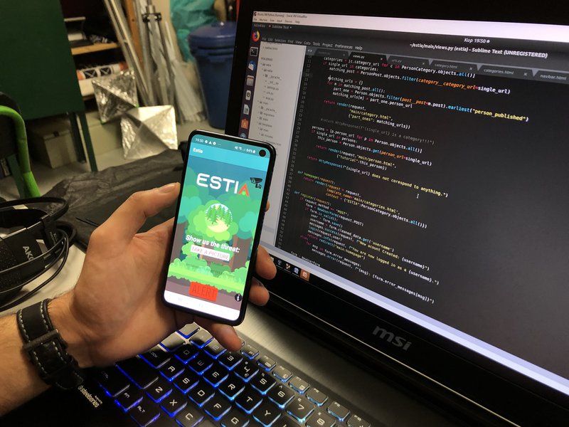
The first step is to register to the database by providing the information in the first picture. Each user decides a username and a password in order to log in to the app. The interface is simplistic and user friendly. The camera icon can show the location of the area’s active thermal cameras. The “Take a picture” button activates the camera of the user’s device and the picture and location are instantly uploaded to a database so that local authorities can process the information and assess the situation. Moreover, nearby users are notified about the reported incident. On the bottom of the screen a big red button appears that can be pressed whenever the user feels imminent threat and will grant him connection with the nearest fire department.
Problems and Current condition
Right now the web and the android applications are unable to communicate with each other due to the unavailability of having a server for them to run on. Additionally, the mathematical formula is currently not fully updated and future thoughts regarding drone usage and thermal cameras haven't been implemented yet.
Sources
- https://openweathermap.org/
- https://www.djangoproject.com/
- https://www.python.org/
- https://www.epa.gov/cameo/aloha-software
- https://www.google.com/maps
- http://fs.fed.us/rm/pubs_int/int_rp115.pdf
- https://courses.chemeng.ntua.gr/industrial_safety/books
- https://pmm.nasa.gov/articles/nasa-rainfall-data-and-global-fire-weather