
Firefighting planner| Spot That Fire V2.0
Project Details
Awards & Nominations
Firefighting planner has received the following awards and nominations. Way to go!
Global Nominee
The Challenge | Spot That Fire V2.0
Your challenge is to create an application that leverages NASA's near-real-time and archival wildfire datasets along with other tools to support firefighting and fire mitigation efforts. This challenge builds on last year’s challenge of the same name by calling for innovative ideas and apps that focus on how to engage and enable citizens to assist with the entire firefighting and fire mitigation process.
Firefighting planner
Collaborative planning tool for fire fighting against wildfire
CONTEXT
A journey of fire fighting can be broken down into the below five steps.
- Refrain from actions potentially trigger a wildfire
- Predict wildfire
- Become aware of incidents
- Evacuation/Firefighting
- Knowledge management
After research, we found many solutions for 1-3, but 4 and 5 seem to have a solution space for improvement. The below three pain points of firefighting based on Ars Technica, European Forrest Institute are our key findings, and our solution addresses them all.
- Communication and coordination among firefighters get more difficult/expensive as a wildfire spreads more broadly
- Leanings and skills from first-hand experiences are not fully shared among firefighters
- Rapid fire fighting planning is required since fire spreads exponentially
SOLUTION
Firefighting planner provides "Collaborative planning tool for fire fighting against wildfire" as OSS.
Three user stories to solve:
- As a citizen, I want to report wildfires and ask for help.
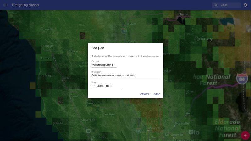
- As a firefight team manager, referring to satellite data and citizen reports, I want to make and share my fire mitigation plan.
- As a firefighter, I want to learn from past fire suppression activities.
See how it looks like:
- Prototype: https://firefighting-planner.dev
- Source: https://github.com/watilde/firefighting-planner
- Open NEX: https://opennex.org/project/projectDetail/275
- Deck: https://speakerdeck.com/watilde/firefighting-planner
WAY FORWARD
Potential impact
- Reduction in burned area: ~8.8 mil acres burned in 2018
- Reduction in losses: ~$12.5 bill insured losses from the 2017 October and December wildfires
- Reduction in # of homes at high risk: 4.5 mil US homes at high risk (2017)
To realize the impact
- Collect more data to increase the accuracy of the simulation model
- Improve the availability of satellite data (FIRMS): Minimize delay, increase grid granularity
- Keep track of fire suppression activities day by day
- Test with real users to improve the usability
- Firefighting simulator to see how the created actions control wildfire
- Discover more potential use cases (e.g. citizen evacuation, and even more: flood, earthquake)
REFERENCES
- https://inciweb.nwcg.gov/
- https://firms.modaps.eosdis.nasa.gov/active_fire/#firms-txt
- https://www.theguardian.com/us-news/2019/oct/11/california-power-outages-cost-business-wildfires
- https://www.nytimes.com/2019/10/06/business/energy-environment/pge-wildfire-victims.html
- http://www.fireparadox.org/suppression_fire.php
- https://www.efi.int/sites/default/files/files/publication-bank/2018/efi_rr24.pdf
- https://www.iii.org/fact-statistic/facts-statistics-wildfires
- https://earthdata.nasa.gov/earth-observation-data/near-real-time/firms/viirs-i-band-active-fire-data
- https://en.wikipedia.org/wiki/Controlled_burn
- https://en.wikipedia.org/wiki/Fire_control
- https://www.iii.org/fact-statistic/facts-statistics-wildfires
- https://www.verisk.com/insurance/visualize/key-findings-from-the-2017-verisk-wildfire-risk-analysis/
- https://www.insurancejournal.com/news/west/2018/11/12/507286.htm
- https://www.nifc.gov/fireInfo/nfn.htm
- https://gigazine.net/news/20180822-isp-throttle-fire-department/
- https://jifpro.or.jp/tpps/conditions/conditions-cat04/f08/