
Mandacaru| Spot That Fire V2.0
Project Details
The Challenge | Spot That Fire V2.0
Last Fire
Chatbot that raising public awareness about wildfires
Background
We believe that raising public awareness is the best way to minimize the damage caused by wildfires. Recently in Brazil we had a great repercussion on the subject, involving wildfires in the Amazon, and most of them were not natural causes because the amazon is one of the most humid places in the world
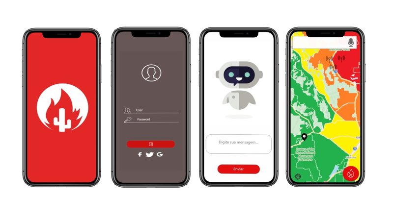
What it does
We built a mobile application that operates in 3 directions:
- Prevention Measures - Hazard zone classification based on NASA fire-related data, the purpose of which is to use technology to search for a pattern of occurrences, enabling the app to interact with the user through a chatbot, which will inform about measures and actions that contribute to the prevention of new occurrences, encouraging him to question himself about his actions in this context.
This information is related to fire prevention in a general and specific manner, depending on the area where the user is.
- Classifying Hazard Zones - Using NASA data with the Modis mapping algorithm, we detect data from likely areas with fire histories, weather conditions such as high winds, low relative humidity, and hot temperatures. Using this, we identify the level of fire hazard of a given localized area.
- Defining escape routes - When a fire is detected in areas around the user, the application will use wind direction and terrain data to calculate the likely route of the flames using Machine Learning techniques and then direct the user to a safe location. , as well as providing quick communication with people close to the site who can offer help while the competent authorities arrive on site. In this same screen there will be an alert button, there the user will inform, in real time, the occurrences of the flames, and can be assisted by people nearby to exit the risk zone through our app or possible partner apps like google maps and waze.
A verification system will be required to attest to driver / passenger reliability.
Nasa Resources
https://earthdata.nasa.gov/earth-observation-data/near-real-time/firms
https://firms.modaps.eosdis.nasa.gov/active_fire/#firms-txt
https://firms.modaps.eosdis.nasa.gov/map/#z:7;c:-41.8,-13.0;d:2019-10-20..2019-10-20
Space Apps Offer
Technical support:
- Miguel Diniz: Creativity and Pitch Mentor.
- Italo Malaquias: Time Management Mentor.
- Marcelo : Design Mentor.
Future Plans
How do we will change the world:
- Reducing invested costs to mitigate and extinguish the fire.
- Reducing wildfires hazard areas
- Population awareness through chat bot learning
- Biodiversity Preservation
- Increase quality of life
The app can be upgraded to help in evacuation cases such as tsunamis, hurricanes, volcanic eruptions, etc.
Built with
Adobe XD - Prototyping
Google Drive - Storage
Trello - Project Management
Google Docs - Write documents
Tags
#Mandacaru #Nordeste #Salvador #spaceapps #spaceappschallenge #spaceappsbr #spaceappssalvador #spotthatfire2.0 #ChatBot #FIRMS #