
R.H.C.P. 451°F| Spot That Fire V2.0
Project Details
Awards & Nominations
R.H.C.P. 451°F has received the following awards and nominations. Way to go!
The Challenge | Spot That Fire V2.0
Rescue Network
We bring network to the people in case of fire
Hi, we are R.H.C.P. 451°F team from Ukraine. Our goal is to save human lives in case of fire in the absence of communication.
Why?
Our goal is saving human lives in difficult situations when there is no hope anymore and people consider themselves doomed to perish because they cannot call for help.
Fires occur annually on the planet and millions of people die in the fire. In case of fire, people often don’t know what to do, and where to run. There are often times when infrastructure is destroyed, and communication with the outside world is lost.
Solution
Being a part of global communication company, we know that network is important for humans.
24/7 we bring one of the most thing in human life - connection.
We understand that in case of emergency, there is too little time to deal with something new. There is no time to find out an appropriate application on phone. There is no time to install it. There is no time to realize how it works.
At the same time, all types of phones already have GSM modules.
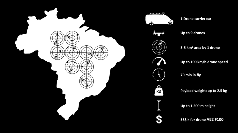
We propose to make a carpet network in a disaster zone (fire). Car with an antenna delivery drones with a transmitter to the disaster area. Drones form in honeycomb format, network. Each of them covers its own area and transmits a signal in it. All of them create one network organism, helping each other to coordinate their movement and share the signal. Each drone could cover 3-5 sq km of area.
All GSM devices that fall within the range of the drone receive notifications. Due to the system that determining devices in the coverage area, these notifications are different and most adapted to the type of mobile device:
1) for all type of phones - receive call, with a brief notice of what needs to be done;
2) for smartphones - receive geolocation of the evacuation zone;
3) for regular phone - receive a text message indicating the street and landmarks where you need to come for help.
In addition, drones equipment recognizes the number of GSM devices in the coverage area, which allows:
1) estimate the number of people in the disaster area;
2) tell the rescuers where people who need help could be situated, and that they could not get out / escape.
At its core, the solution makes a sonar from the drone. Namely, the drone is acquirable the ability to recognize the device, to identify it and to sends a notification to it by sending and receiving a signal.
In Ukraine we can use RTM platform (real time marketing) for target notification GSM devices in the specified location.
Paradise city
November 9 2018, California, Paradise city
Over 5k firefighters
622 units of special equipment
21 helicopters
71 water tankers
The city of Paradise has been burned almost completely
Area of the fire was over 300 km2.
77 people died, and about a thousand people are missing. Some of them died in cars and some in their houses .
With our solution 2 car "drone carriers" with 9 drone on each could cover 100 km2 of area and inform people where is zone of evacuation.
Being a mobile station, it can move and broadcast the signal throughout the disaster area.
We believe, when everyone is awarned of what to do, less deas would be.
Calculation
58k $ - approximate cost of 1 drone AEE F100, that could carry communication equipment.
500k $ - approximate cost of 1 car "drone carrier".
50k $ - approximate cost communication equipment.
Future
With this solution drones could be useful in floods, earthquakes, and other disasters. They can find climbers after an avalanche.
Drones could be connected with future technologies such as LPWAN or StarLink.
Drones could have air and radiance pollution indicators, to verify whether the area is saved for human or not.