
Project Details
The Challenge | Spot That Fire V2.0
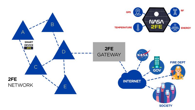
FOREST FIRE EYE (2FE) - INTEGRATED NETWORK
Our 2FE devices with RF create a network that detect high temperature, to transmit a signal to next device to near city. Then cross our data with NASA (wind, heat, topography) to predict the near risk areas. Notify authorities and society in real time
Challange
Faster way to identify the fire at the beging, generate primary data to cross with NASA to minimize the fire effects and warn the civil society in real time
project
Our 2FE devices with RF create a network that detect high temperature, to transmit a signal to next device to near city. Then cross our data with NASA (wind, heat, topography) to predict the near risk areas. Notify authorities and society in real time
THE NETWORK
A integrate wirelless network inside the forest, and in case of high temperature, one device will send a signal to the next device till the network gateway to access the internet. Crossing with NASA data (wind direction and speed, temperature of the near areas and topography) we can determinate the risk areas.
This information will be crucial to the authorities to fight the fire!
The civil society will be warn since the begin of the fire and than updates with real time information - to stay home safe, the near safe place and routes
2fe devices
2FE will be a simple divice with four components: Radio in low frequencies (does not need internet or satelities at inhospitable lands), a GPS, a energy source and temperature sensor.
It is small device (5cm to 5cm) and with a 60cm to grile to land on the top of the trees.
create the integrate network
With all NASA fire data, we can determinate the most probally fire area. Than with topography data we can map where to install each device. The device will be at least 500 meters from each other. That way, each device will be connect with more than one device.
We can build a network that cover big areas (like 60M hectare²) in a year with drones, helicopters and airplane.
With a simple low radio frequency, the device will send a "yes" or "no" for high temperatures - one frequency to each information. This information will propagated by will devices on the network until it reach a gateway.
In the base, we get the data of what device alert high temperature, determinate the fire start area location. If other device alert after that, we could beging to predict the direction and speed of the fire.
Than we cross with NASA data to improve de information and fire forecast to send alerts to the stakeholders
future vision
Possibility to trigger drones for live straming. Improving the information for the authorities.
It,s a low cost device and solution, especially comparing with the high cost of lost bio diversity and life all the destruction potential of big fires.
This solution can be install at any inhospitable land to prevent and alert big fires since the beging.
source
https://earthdata.nasa.gov/earth-observation-data/near-real-time/firms
https://firms.modaps.eosdis.nasa.gov/map/#z:3;c:0.0,0.0;d:2019-10-19..2019-10-20