
Project Details
Awards & Nominations
airsat has received the following awards and nominations. Way to go!
The Challenge | Surface-to-Air (Quality) Mission
AirSat
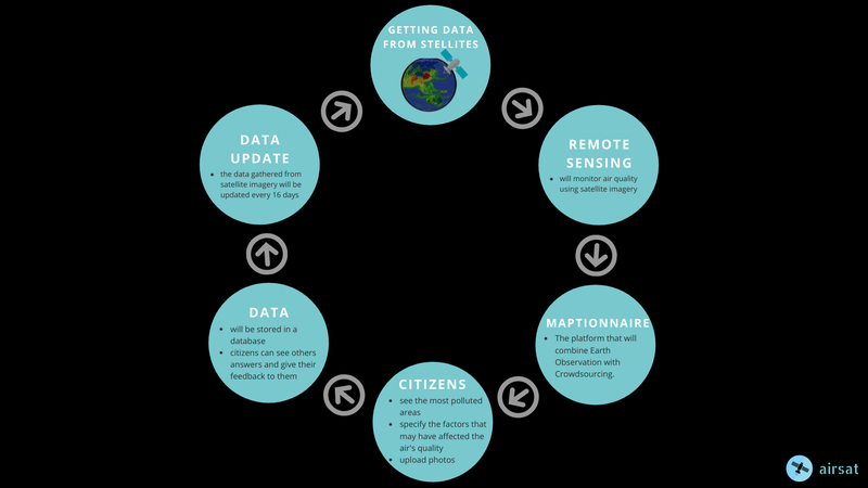
AirSat is a user-friendly platform that combines earth observation with crowdsourcing. It brings citizens to change detections.
Problem:
Air pollution is associated with 5 million annual deaths worldwide, negative health impacts, and it costs the global economy trillions of dollar ($) losses annually.
Citizens do not have enough information about the pollutants that the air stores. Therefore we need to integrate NASA data, ground-based air quality data, and citizen science data to create an air quality surface that displays the most accurate data for a location and time.
Solutions:
- We have used Remote Sensing to monitor the air pollution index and to find air pollutants.
- Displaying informations on a map, that is user-friendly and in which people can combine data from NASA’s satellites with their data (uploading photos and present the factors that have affected the air quality).
- The data will be stored in a database. Citizens can see others answers and give feedback to them.
- We have included Aerosol Index, but in the future we are going to also add Aerosol Optical Depth, Carbon Monoxide, Dust, Fire, Sulfur Dioxide, Ozone, Nitric Acid.
- We have developed air quality surfaces in many locations. Satellite images are updated every 16 days.
Bringing citizens to change detection.Tools:
- WorldView
- QGIS
- Maptionnaire
- Adobe illustrator
- Camtasia
Resources used from NASA:
1. https://earthdata.nasa.gov/earth-observation-data/near-real-time/hazards-and-disasters/air-quality
2. https://worldview.earthdata.nasa.gov/
3. https://www.epa.gov/hesc/rsig-data-inventory