
Project Details
The Challenge | Out of This World!
Gyrodorse
Gyrodorse helps to control drone by gyroscope with map and compass which can show the live location of the drone to prevent the drone from missing. We also created autopilot and planet scalling features which makes it the most unique drone controller app.
motivation
Everyone was wondering what if something goes wrong during mid-flight and the autonomous controls do not work correctly? Multiple complications could arise. The drone could start to lose altitude, fly off course into dangerous terrain and weather, or have an uncontrolled landing while engineers are developing new solutions for autonomous controls to be repaired. In the meantime, a drone pilot could take over control of the drone for the safety and protection of multi-million- or multi-billion-dollar equipment and experiments that are aboard the drone.
However, there would not be a human on the planet to repair the drone, so imminent response manual control is vital to the mission(s). The transmissions delay between Earth and the exploratory planet will have a huge impact on the response, so intuitive controls will be ideal for the pilot and drone.
We Team Indorse, created an app name GYRODORSE, an app to control a drone by gyroscope with map and compass which can show the live location of the drone to prevent the drone from missing. The above is the common one, the features which make us special from the others are autopilot and planet scaling.
Solution
We have created an app which can control the drone easily with cutting edge technologies plus features. It simulate the feeling of piloting a real aerial vehicle through phone's features such as real voice recognition and etc. This app is also friendly to beginner using the autopilot feature which can take off, fly and landing automatically.
You might ask how? This is because our autopilot feature is directly connected to our map and compass feature. The map has a unique feature which is way points. What is way points? A way point is an intermediate point or place on a route or line of travel, a stopping point or point at which course is changed,[1][2] first use of the term tracing to 1880.[2] In modern terms, it most often refers to coordinates which specify one's position on the globe at the end of each "leg" (stage) of an air flight or sea passage, the generation and checking of which are generally done computationally (with a computer or other programmed device).[1] We just a tap of a button, the drone will be able to return to its position by itself without the need of a pilot.
Maneuvering the drone is made 10x easier by utilizing the inbuilt feature 'compass', the compass will guide the pilot by showing direction relative to the geographic cardinal directions. This feature is very useful especially to professional pilots who prefer to control the drone themselves. The way point will also be shown in the compass.
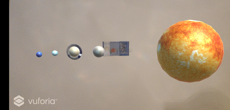
It amazes us when we realize that most of our friends didn't know that the size of the Earth when downscale is smaller than a peanut when compared to the Sun. Therefore, we strive to think of an idea that could open people's "eyes" and we came up with 'Planet Scaling'. Planet Scaling is a feature that displays AR planets or stars that is scaled down in the pilot's desired ratio. Planets and stars will appear in the controller's display and this will truly show the people how small we are in this vast universe.
Main features of gyrodorse
- Controller
- Gyroscope
- Map
- Way point
- Compass
- Planet Scaling
- Autopilot
Resources used from NASA
Planet Scaling
- Solar System Information: https://solarsystem.nasa.gov/solar-system/our-solar-system/overview/
- Mercury Scale: https://solarsystem.nasa.gov/planets/mercury/overview/
- Venus Scale: https://solarsystem.nasa.gov/planets/venus/overview/
- Earth Scale: https://solarsystem.nasa.gov/planets/earth/overview/
- Mars Scale: https://solarsystem.nasa.gov/planets/mars/overview/
- Jupiter Scale: https://solarsystem.nasa.gov/planets/jupiter/overview/
- Saturn Scale: https://solarsystem.nasa.gov/planets/saturn/overview/
- Uranus Scale: https://solarsystem.nasa.gov/planets/uranus/overview/
- Neptune Scale: https://solarsystem.nasa.gov/planets/neptune/overview/
- Solar System Exploration: https://solarsystem.nasa.gov/solar-system/sun/by-the-numbers/
- Final Year of NASA Research: https://www.nasa.gov/feature/ames/big-city-life-awaits-drones-in-final-year-of-nasa-research
Development Process
- A design of a normal app to control a drone was planned partially and some cutting edge technologies plus features were added
- All the scripts were written in MIT App Inventor
- To create an app to control a drone extraordinary
- To show the people how small we are in this vast universe
- To have better user experience point and select system is used in this app
- To keep the cost as low as possible MIT App Inventor was targeted for production usage.
Tools Used
- MIT App Inventor
- Android Phones
Checkout
- Gyrodorse app for android: https://drive.google.com/open?id=1kpjljRYMffuGsokNp9LLqaTcButU7r5R
- Planet Scaling : https://drive.google.com/open?id=1xWbegllP1FK_JjchRQ36VnRwvTbRbE7Y
- Gyrodorse website:https://sites.google.com/view/indorse/home