
Signal Life| Internet on the Ocean
Team Updates

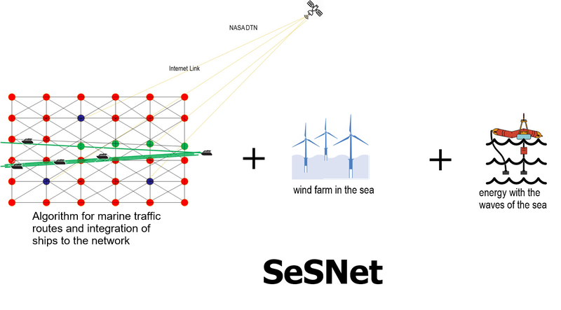
The solution is to build floating marine stations with wireless communication systems capable of propagating and expanding the Wifi or WiMax network to users or applications within a radius of 12 square miles per node, each station must be self-supported in its power generation by hydraulic and solar means, then each station will be a network node that we will call Sea Buoy Station (SBS).
When floating, they will have a form of navigation taking advantage of the expulsion of seawater that comes out of the turbine, thereby correcting their position within a defined and assigned range.
Each station will have a way to connect and register users, with the Access Bouy Station (ABS) application, this to intersperse the use of available technologies such as DTN, WiFi or WiMax, for users, applications, devices or sensors.
The network will be called SeSNet which is scalable by the number of SBS nodes and compatible to integrate different technologies already existing at sea.
Energy
Because we need at least 400 watts of maximum power from our radio for WiMax transmission, plus the communication equipment for the data network approximately 60 watts and the data processing and instrumentation equipment we would be talking at a maximum power of 460 watts.
To solve this need for energy we will be generating energy through the waves of the sea with two pistons connected to a water turbine, pushing the seawater towards the turbine, with this movement we are calculating to generate 500 watts, additionally 4 solar panels will be installed with a maximum generation of 80 watts, this to leave a remnant of energy, for battery charging through the energy manager system and the intelligent inverter.

Far from imagining that there is no great demand for internet services on the ocean, since we do not travel most of the sea or we do not spend much of our time in the ocean, coupled with the fact that there are currently many areas in the different continents where the internet does not arrive, it would lead us to conclude its null feasibility or bad investment the implementation of internet infrastructure on the ocean.
However, there are data such as MarineTraffic.com shows the position of virtually every commercial naval vessel in the world (800 million positions per month). In addition to being visually impressive, the map is an interesting way to visualize the flow of people and goods around the world: where the hot spots are and where they are not.
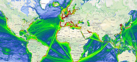
Map of the Day: All the World’s Maritime Traffic
However, there are data such as MarineTraffic.com shows the position of virtually every commercial naval vessel in the world (800 million positions per month). In addition to being visually impressive, the map is an interesting way to visualize the flow of people and goods around the world: where the hot spots are and where they are not.
Ships are color coded by type:
Green = Cargo Ship
Red = Tanker
Purple = Pleasure Vessel
Blue = Passenger Vessel
Cyan = Tug or Special Vessel
Orange = Fishing