
Satellite cleaners| Trash Cleanup
Project Details
The Challenge | Trash Cleanup
Satellite cleaner
Satellite cleaner is an app that guides cleaning ships to high concentration areas of microplastics on the surface of the ocean using Nasa satellite imagery and other measurement like Temperature, UV index, Wind currents and image recognition.
Background:
Ocean pollution caused by plastics is a global problem that requires careful planning of cleanup missions as part of the solution. However, since the task is so overwhelming in terms of geographic extent and resource use, prioritization of cleanup locations is necessary.
Promising and already existing plastic cleanup initiatives focus on the use of floating devices to capture debris in garbage patches, but there is evidence that suggests that shores are also a target we should be considering.
There is a discrepancy between the amount of plastic being released into the oceans and the amount scientistshave been finding on the surface of the ocean. Recent research suggests that a fraction of the missing plastic is undergoing a cycle in whichafter its initial release, it goes back on land before returning to the sea. This process is probably repeated several times (The Ocean Cleanup, 2019).
According to a global assessment by GESAMP (2015) “The production of microplastics by the fragmentation of larger plastic items is most effective on beaches, with high UV irradiation and physical abrasion by waves. Once submerged, cooler temperatures and reduced UV means fragmentation becomes extremely slow”. This means that whenever there is High temperature and High UV radiation, the fragmentation of macroplastic to microplastic is high.
Satellites can measure both temperature and UV radiation using Ozone as reference. They can also determine sea currents which means they can be used to predict the path of microplastics and high concentration areas. This highlights their potential as a tool to determine areas that should be prioritized for cleaning.
- Input Data so far: Coasts/Shores/Rivers close to mega cities, Temperature, UV radiation, Sea currents maps, Wind movements, and Shipping routes.
- Output Data so far: Localization of high concentration areas of macroplastics and microplastics. Optimal sea route for cleaning boats.
Once the locations are determined, our strategy for cleaning should be as environmentally friendly as possible, that is why we plan to use boats powered by fossil fuels only in the first stage, after that we will use the same plastics that were captured and recycle them to build plastic solar boats for future cleaning operations. Satellites will guide these solar boats using GPS through the max solar irradiance route so that the boats will function at their max power. Solar boats speeds can reach up to 8mph (12,8 km/h) in normal mode and can go up to 56 miles in the dark (90,1km) if there is no sunlight. Microplastics can travel up to 3500km in seawater.
Our Solution:
To create a system capable of identifying priority locations for coastal cleanup missions.
Development process:
We decided to train machine learning algorithms using satellite imagery and variables such as proximity to urban areas, shipping routes and environmental variables. Our system can coordinate the movement of all satellites for optimal use.
How the main algorithm works:
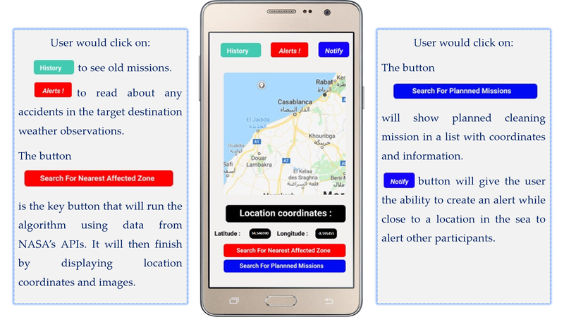
First it starts by searching for a list that has mega cities, and within this list it will search for cities that are near the coast. In coastal areas it will retrieve temperature measurements, and previously specified UV indexes. Then it will go further following sea currents and wind data, and it will start taking pictures and analyzing them for macroplastic recognition. For microplastics, the algorithm will try to predict areas with high concentrations of plastics. The system will retrieve the coordinates using a Nasa API called Earth, and display the results on the app. (All this happens when the user hits "search for nearest affected zones".)
Then implementing and training the model as well.
Challenges faced:
One of our biggest challenges was working in different time zones around the world, and with different skills!
Our group is formed by a biologist from Paraguay (Marcela), another biologist and student of geosciences and mathematical sciences from Brazil (Quezia), and an electrical engineer from Morocco (Mohamed).
Resources used:
- Sea Surface Temperature:
https://catalog.data.gov/dataset/noaa-climate-data-record-cdr-of-sea-surface-temperature-whoi-version-1-0
- Shipping fairways (routes):
https://catalog.data.gov/dataset/shipping-fairways
- World wind power measures:
https://catalog.data.gov/dataset/world-wind
- Solar radiation:
https://catalog.data.gov/dataset/national-solar-radiation-database-nsrdb-solaranywhere-10-km-model-output-for-1989-to-2009
Mega cities Industrial areas:
- (Retail spending potential) https://catalog.data.gov/dataset/retail-spending-potential
- (Industrial areas) https://catalog.data.gov/dataset/industrial-areas-2004-east-baton-rouge-parish-louisiana
Future Considerations:
We plan to build a multinational NGO to help other environmental NGO's be more efficient in their cleaning missions.
