
EDIFIED Eco-Warriors of DLSL| From Curious Minds Come Helping Hands
Project Details
The Challenge | From Curious Minds Come Helping Hands
Bastions
EDIFIED ECO-WARRIORS uses NASA/JPL's MODIS-JASON constellation of satellite data to show communities hit by storm surges and sea level rise. They design SMART CITY BASTIONS of SUSTAINABLE LIVING based on UN Agenda 2030 for expansion and relocation areas.

We propose the establishment of SMART CITIES AS BASTIONS of SUSTAINABLE LIVING strategically located to serve the most vulnerable coastline and river valley communitiesand fully aligned with the United Nations Agenda 2030. Both can be identified using NASA DATA mapping the critical factors of oceanography, topography, meteorology, demography and geography. The team was able to utilize a selection from the myriad of satellites NASA has such as those under JPL and MODIS for the development of the project. Data from 4 satellites, specifically the Jason 3 satellite for obtaining data that measures sea levels, the AIRS satellite that measures atmospheric pressure and global temperature, the IMERG satellite that gathers precipitation measurement, and the MODIS satellite to monitor the cover of clouds and its properties, were tapped for credible and useful information. Tingkercad and Sketchup was used to design the 3-D CAD of the smart city whilst Adobe Photoshop and Adobe Premiere Pro was used for the making of some visuals for the MS PowerPoint presentation.
1. Why did we choose this challenge?
The majority of people in the Philippines live in coastal plains and river valleys that are threatened by both long term sea level rise and episodic severe weather events, such as the average 20+ typhoons that visit the country every year. We have chosen this solution with the observation that climate MITIGATION efforts worldwide are faltering, and that it is time to undertake strategic ADAPTATION measures. It appears that we are not alone in this assessment that the time has come for these type of measures as the Indonesian Government has announced a project to move their capital (Djakarta) to the island of Kalimantan at a cost of $32.7 billion starting in 2024. This establishes a rough scale of the economic costs based on relative population size to the 10 million in Djakarta.
2. What does it do?
We propose the establishment of SMART CITIES AS BASTIONS of SUSTAINABLE LIVING strategically located to serve the most vulnerable coastline and river valley communities and fully aligned with the United Nations Agenda 2030. These bastions accept the likelihood that the present locations of dense human settlements at low elevations will become more and more unsustainable. Thus the systematic movement to higher more secure locations makes sense. The primary product is an evolving toolkit for government and community leaders, both local and national that incorporates into the basic idea of a SMART CITY the following features: (1) defensible, secure and sustainable location; (2) renewable energy resources; (3) transportation grid; (4) livelihood resources; (5) waste plastic management; (6) fresh water availability; (7) advanced manufacturing technologies for dwellings and structures.
What is a smart city?
A smart city is heavily inclined to the use and design of technology, people-centred focus, and sustainable practices to support human living (Yap, 2019).
Some Included Features of the smart city:
1.Residentials – Residentials, roads, and infrastructures constructed from reused plastic as construction materials.
2.Agriculture- Utilizes the use of bio-domes and aquaponics for crop cultivation and food sourcing.
3.Energy Source- Solar powered streetlight as well as decked solar panels will be be established to be a source of sustainable energy.
Bio-domes - are enclosed, controlled, and self-sufficient ecosystems that replicates the natural external environment (Brook, 2018).
4.Transportation Grid and urban design- Implements the integration of “Superblocks” as the urban layout for the smart city.
Superblock - an urban planning design/model that aims to lessen vehicular activity and increase public space;it reduces air pollution, noise, and heat whilst providing positive health impacts to the residents. (Mueller, et al., 2019).
Short vIdeo presenting the model of the proposed smart city:
https://www.youtube.com/watch?v=j4IivV1-2aA
3. NASA RESOURCES
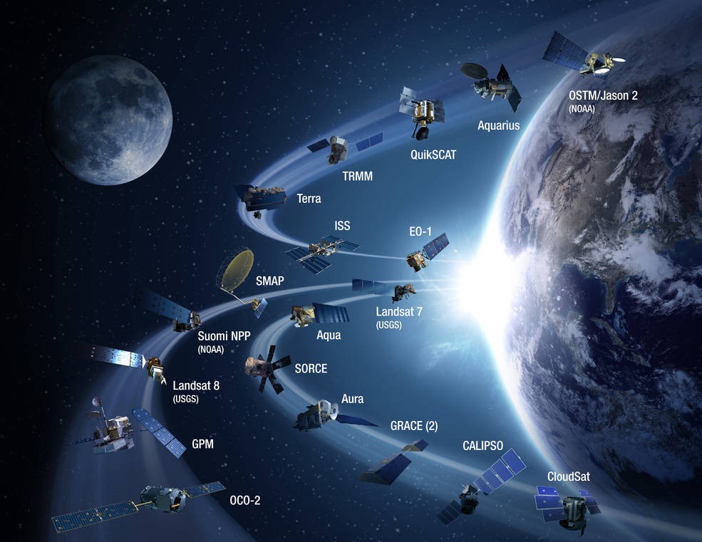
The principal use to which we have put NASA resources was in the selection of the most vulnerable communities and that of the alternative bastion location. We rely heavily on land, sea, and atmosphere data bases available from the constellation of remote sensing satellites run by jointly by NASA, JPL, NOAA pointed too at sites like climate.nasa.gov and earthdata.nasa.gov. For severe weather information and histories, the Moderate Resolution Imaging Spectroradiometer (MODIS) sites contained a wealth of information. It's visible and infrared sensor based data provides a large spectrum of information on various aspects that would impact any project of this scale that we are contemplating. At the same time, the free and ready availability of this data makes it very attractive to the long term progressive planning required to accomplish this mission. We particularly appreciated the information on recent severe weather events like Typhoon Hagibis and the 2018 Typhoon Haiyan disasters. If we had any failures during the Challenge it would have to be the inability to absorb or even sample the deluge of information that is available. However, just know what is there and how to access it later is already an invaluable assistance to us. The panoply of satellite based data available from NASA is shown in this graphic which we have used in our presentation is this one of the satellites producing the tidal wave of data:
4. We did not take advantage of any specific Space Apps offers.
5. Future Plans
Our educational institution (De La Salle Lipa) is fully committed to the United Nations Sustainable Development Goals (Agenda 2030). Our particular project of moving or transforming vulnerable communities into smart city bastions is only a part of the institution's overall and long term committments. Our main purpose in joining the Space Apps Challenge was to be able to identify the kind of data and information resources we will need to undertake this project. We are targeting government and community leaders and have no illusions that these objectives can be easily or quickly accomplished.
6. Built With
Our project is built around an appreciation and understanding the United Nations Sustainability Development Goals, reduced to engineering, economic and sociological specifics by the U.S. National Academy of Engineering's 14 Grand Engineering Challenges for the 21st Century.
7. Tags:
#indonesia #djakarta #kalimantan or Search Google for "Indonesia to move capital from Djakarta to Kalimantan"
#sealevelrise #Hagibis #Haiyan #hurricanes #cyclones #3dprinting #solarenergy #freshwater #wasteplastic #smartcity #circulareconomy
Materials used by the team: https://drive.google.com/folderview?id=1hsg50B8z8mIFuEWGg0zvFtiXAxCpZcxy
Citation and References:
Przyborski, P. (2013)Earth observatory. NASA Retrieved from: https://earthobservatory.nasa.gov/images/event/82342/typhoon-haiyan/ on October 19, 2019
Jackson, R. (N.D.)Global Climate Change. NASA Retrieved from: https://climate.nasa.gov/ on October 19, 2019
Maccherone, B. (N.D.) Moderate Resolution Imaging Spectroradiomer. NASA Retrieved from: https://modis.gsfc.nasa.gov/about/ on October 19, 2019
Claudino, P. (2016). Experimental and Modelling Study of a Geodesic Dome Solar Greenhouse System in Ottawa (Doctoral dissertation, Carleton University). Retrieved from: https://curve.carleton.ca/693405ce-0d3a-4fc4-87bd-a1666d6dc5f9 on October 19, 2019
Reports on the effects of typhoon Haiyan/Yolanda in the Philippines:
Richard, S. O. L. I. S. (2013, November 29). Europe Solidaire Sans Frontières. Retrieved October 20, 2019, from https://www.europe-solidaire.org/spip.php?article30501.
Reid, K. (2019, August 19). 2013 Typhoon Haiyan: Facts, FAQs, and how to help. Retrieved October 20, 2019, from https://www.worldvision.org/disaster-relief-news-stories/2013-typhoon-haiyan-facts.
Hodal, K. (2013, November 10). Typhoon Haiyan: at least 10,000 reported dead in Philippine province. Retrieved October 20, 2019, from https://www.theguardian.com/world/2013/nov/10/typhoon-haiyan-thousands-dead-philippines.