
Megha Naada - The Sound Of The Cloud| From Curious Minds Come Helping Hands
Project Details
The Challenge | From Curious Minds Come Helping Hands
Your challenge is to design and build an innovative platform to integrate satellite data and information about vulnerable populations and environmental hazards in order to identify the most at-risk populations. Be creative and think outside the box. How will you identify those people that are often missed, but need aid the most?
MEGHA NAADA - Sound of the Cloud -
Innovative Integration for Intervention - While property damage from rising waters and collapsing hills is unavoidable, loss of lives can be minimized with early warnings and timely evacuations using readily avialable NASA data. "We must practice empathy"
Team Megha Naada - The Sound Of The Cloud
(Megha means cloud. Naada means sound. Everything based on clouds these days)
Innovative Integration for Intervention
- Would you believe that there are some regions on earth that innocent public has to pay from their lives for not having access to information much needed? Yes! While data giant NASA having all the data readily available for public which could be used for disaster response when they are fully integrated, still people pay the price for not having a robust disaster management plans due to lack of technical knowledge or not having the creative technical attention to detail eye to think outside the box. We are a team of Space Activists, Software Engineers, Environmental Engineers, Disaster Relief Professionals, Humanitarian Activists, Creative Design Specialists, AI Consultants and Social Experiment Vloggers and we all have affected by a natural disaster and have worked in Disaster Relief.
- Tropical cyclone Roanu - 2016 - Sri Lanka was the worst hit — and, as it turned out, also the least prepared country to cope with the impacts. On 15 May 2016, Sri Lanka was hit by a severe tropical storm that caused widespread flooding and landslides. in 22 districts out 25 districts in the country, destroying homes and submerging entire villages. At least 104 people are known to have died following this disaster; 99 people are still missing, many as the result of a landslide in Aranayake, Kegalle District, which devastated three villages. An estimated 301,602 people have been affected by this disaster, including at least 21,484 people who remain displaced from their homes. (OCHA, 26 May 2016)According to official estimates, between 25,000 and 30,000 businesses were impacted, most of them small enterprises. In a preliminary assessment, the finance ministry placed the economic loss at around US$2 billion, equal to 1.6 per cent of total GDP.
- While property damage from rising waters and collapsing hills is unavoidable, loss of lives can be minimized with early warnings and timely evacuations. And after disasters hit, better information sharing can improve the rescue and relief efforts. Technologies can help this endeavor, provided they are integrated into overall systems and anchored in good policies and practices. Since 2005, Sahana website has evolved into a global free and open source software project supported by hundreds of volunteer contributors around the world. It has been used by relief agencies responding to sudden-onset disasters in locations as far apart as Haiti, Japan, Pakistan, the Philippines and the United States.For unknown reasons, Sahana has not yet been implemented in Sri Lanka. The disaster management ministry has acknowledged there were gaps in the official response.
- The Importance of Flood Mapping
It helps to effectively communicate flood risk to all the vulnerable communities.
It gives user friendly and quickly accessible maps which assists to identify the areas at risk of flooding.
It helps people to respond quickly to coming disaster.
It will acts as an information system to improve the awareness of risk.
Flood Mapping is useful for arrange suitable land use planning in flood-prone areas. - Factors which increase the flooding•Poor patterns of land-use •Uprooting of Bamboo bushes along the banks •Unstable river banks, which are a result of sand mining•Blocking of downstream waterways •Construction in water retention areas•Extensive harvesting of jungle poles and bamboo for temporary construction•Illegal sand mining •Inappropriate disposal of debris•Filling of low-lying water retention areas •Dumping in ecologically sensitive areas (Ref: SRI LANKA FLOODS AND LANDSLIDES - MAY 2017 / RAPID PDNA REPORT)
- Major floods in Sri Lanka are associated with the two monsoons. Typically, during the Southwest monsoon season (May-September) the western, southern and Sabaragamuwa provinces are vulnerable to floods. During the Northeast monsoon (December-February) the eastern, northern and north-central provinces are prone to flooding. Rivers along the western slopes of the hilly central areas cause floods in the lower flood plains of Kalu Ganga and Kelani Ganga in particular during these periods. (Ref: DMC)
- https://worldview.earthdata.nasa.gov/?v=3.819401617075556,-10.419151331448774,206.6416827841843,89.14334866855123&t=2019-10-20-T07%3A14%3A49Z
- https://pmm.nasa.gov/sites/default/files/document_files/TMPA-to-IMERG_transition_0.pdf
- Flood 2018The southwest monsoon weather conditions have caused rainfalls since 19 May 2018 in the southwest parts of the island. By 21 May, the precipitation triggered a flood and landslide situation in the country, which has affected thousands of lives and livelihoods, as well as caused property damage. According to the situation update by the Disaster Management Centre (DMC) of Sri Lanka confirmed that a total of 153,7122 people in 19 districts have been affected and 20 people have died due heavy rains, strong winds, lightning and landslides. Currently, 19,519 families have been evacuated into 339 welfare centres. Puttalam, Gampaha, Ratnapura, Colombo, Kurunegala, Kalutara and Kegalle are amongst the worst affected districts. The water levels of two main rivers, Kalu Ganga and Attanagalu-oya, are still at flood levels, but slowly receding. Some water reservoir gates are opened and release water to reduce the flood threat to other areas. Landslide warnings are still active in some districts due to the risk of landslides and power cuts and failures.As of 1 June 2018, water levels in all major rivers had decreased and flood victims in over 200 welfare centres had returned to their homes. The flood affected 174,310 persons from 45,680 families. Twenty six persons were reported dead. The Puttlam district had the highest number of victims stranded at safety centres, as well as the highest numbers in flood damage with 96 critical infrastructure, and 53 fully damaged houses. Colombo recorded the highest number of partially damaged houses with a total of 2,270. While waiting for the damage assessment report, the National Disaster Relief Service Centre (NDRSC) disbursed Rs. 25 million to meet the costs of immediate response, in addition to Rs. 55.45 million provided for emergency relief assistance. (Govt. of Sri Lanka, 4 Jun 2018)As of 12 June, the DMC has reported that close to 175,000 people have been affected across 19 districts, and 26 people killed. Puttalam, Gampaha, Ratnapura, Colombo, Kurunegala, Kalutara and Kegalle are amongst the worst affected districts. (ECHO, 12 Jun 2018)Sri Lanka Summary Situation Update - 1300 hours, 26 September 2019Highlights•As of 1200 hours 26 September 2019, 136,607 people (35,000 families), mainly in six districts, are reported to have been affected.•As a result of the heavy rainfall, strong winds and landslips, 66 houses have been fully damaged, with a further 2,572 receiving partial damage across the country.•86 safety locations have been set up to assist those most impacted, or whose houses have been inundated by the heavy rainfall. From the most recent information received, 1200 hours 26 September 2019, there are people 45,407 (11,003 families) who have evacuated to the 86 locations. Most of these locations have been set up in the Gampaha and Colombo Districts.•Total of LKR 43.1 million has been provided to the affected districts to address the emergency needs.•15.78 million for house damage insurance, 25.84 million for relief , and 1.50 million for response.•Tri Forces and the police have been deployed on search and rescue and other emergency response purposes in the affected districts particularly in Kalutara, Galle, Matara and Ratnapura.•Department of Meteorology updated that atmospheric conditions are favorable for evening thundershowers over parts of the country. Showers or thundershowers will occur over most parts of the island in the evening or night. Fairly heavy falls about 75 mm are likely at some places in Sabaragamuwa, Central and Uva provinces. Several spells of light showers will occur in the coastal areas of Westem, Southem and North-western provinces as well.•As predicted, the majority of the very heavy rain conditions in the South-western eased yesterday evening and into today.CURRENT SITUATIONThe storm that swept across several parts of Sri Lanka, beginning in the afternoon and evening of 23 September 2019, has subsided since the early morning of 26 September 2019. The storm caused heavy rains, flash floods and landslide alerts covering nine districts, across the Western, Sabaragamuwa, Southern and Uva Provinces.As per the Department of Meteorology, rainfall received within the past 24 hours, as of 0900 hours on 26 September, has been concentrated in the Districts of Galle, Kalutara, Monoragala, Gampaha, Ratnapura, Kegalle, Matara and Batticaloa. Only five areas in the country recorded rains above 50mm, Thaldoowa and Matugama (Kalutara District) received the most with 71mm each. As predicted Batticaloa also received high amounts of rainfall.As a result of persistent heavy rains, 136,607 people (35,000 families) have been affected (Situation Report, DMC at 1200 hours on 26th of September 2019). There have been no additional deaths, but seven people remain injured. Additionally, 66 houses have been fully damaged, with a further 2,572 receiving partial damage. 68 safety locations have been established in four Districts with 45,407 people (11,003 families) evacuated into them.Department of Irrigation has alerts remaining in four river basins, however, the water level in all areas is falling.One stations - Baddegama, Gin Ganga - still sits at major flood levels but is falling (Figure 02). Punadugam on Nilwala River fell below major flood levels this morning as well.As predicted by the Department of Meteorology, conditions in the South-western areas have reduced. However, fairly heavy falls about 75 mm are likely at some places in Sabaragamuwa, Central and Uva provinces. Spells of light showers will occur in the coastal areas of Westem,Southem and North-western provinces as well. Atmospheric conditions are also becoming favorable for evening thundershowers over parts of the country.
- https://media.ifrc.org/ifrc/
- https://pmmpublisher.pps.eosdis.nasa.gov/swagger/index.html
Our pitch
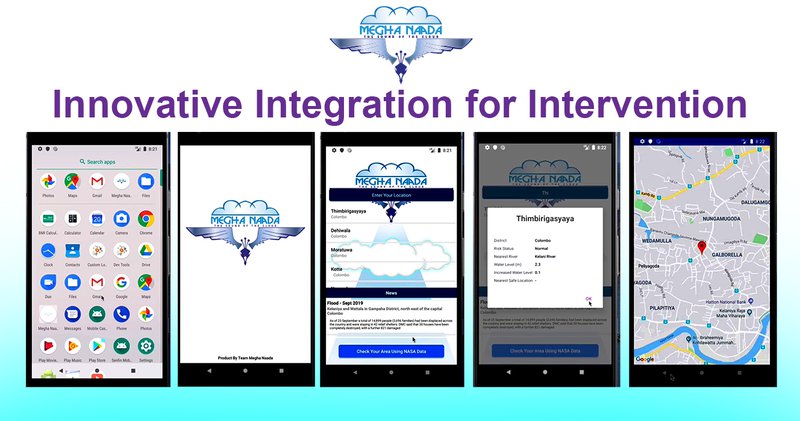
- Would you believe that there are some regions on earth that innocent public has to pay from their lives for not having access to information much needed? Yes! Sometimes they still use traditional communication medium like loudspeakers and megaphones to warn residents at risk caused by the heavy rainfall. Yes you heard right.However loss of lives can be minimised with early warnings and timely evacuations. And after disasters hit, better information sharing can improve the rescue and relief efforts and insurence processes. Technology can help this, provided they are innovatively integrated for intervention.We introduce Megha Naada - The sound of the cloud- A robust flood warning system app, based on live NASA data and this will be available for the public to download into their mobile phones free of charge and this will lead to a better flood warning and disaster response system. This system will easily allow people to type locations and receive warnings, evacuation roots, traffic maps, time left for evacuation, risk maps and many more features. This will give enough time to save most vulnerable elderly people, younger children and to save your live stock and loving pets too. Team Megha Naada has a validation from Disaster Management Center Sri Lanka and from an active Humanitarian communication and community engagement consultant. Team Megha Naada - A team with empathy!
We are planning work on our solution and test and release launch it in Sri Lanka in the coming few weeks. And we have plans to open invite Big data companies in Sri Lanka to support this project with back end.
And we have conducted a poll on social media admin page and we got voting in favor of an app.
code repository(e.g., GitHub)https://github.com/roshanevala/Megha-Naada?fbclid=IwAR3ya6rnKu_7SudVSx5FzbUWGqsCtb9viO4jfhD1nAcjbiTJ7rC5RshSQlY