
SafetyOnWater| From Curious Minds Come Helping Hands
Project Details
The Challenge | From Curious Minds Come Helping Hands
Safety On Water From Dangerous Animal
Our #App will help people to prevent them to get attacked by dangerous animals near any lake by showing live location of dangerous animals
Make User be aware of Dangerous Animal around any Lake in the Globe:
We are been hearing a lot about incidents took place around the lake’s(where people normally take walk or visit to have fun
Dangerous Animal like: Bear , coccoidal… etc. had attracted human beings
News Links:-
- https://www.miamiherald.com/news/local/community/broward/article212808339.html
- https://www.earth.com/news/habitat-destruction-crocodiles-indonesia/
- https://www.ctvnews.ca/world/philippine-boy-eaten-by-croc-in-latest-attack-1.4548969
Our #App will help people to prevent them to get attacked by dangerous animals by showing live location of dangerous animal near Lakes
#AutomationScript: To get Live Data
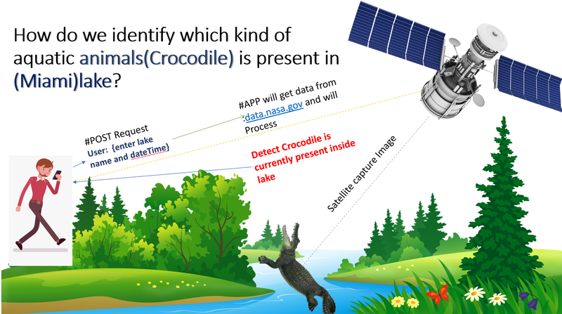
STEP 1: POST Request
- get details from User (lake name, dateTime) and call below API
- API : safeonwater.com/api/user/{pinkey}/lake/{miami}/dateTime/{2019-10-19T12:36:57.704Z}
STEP 2 :GET Request
- Get Images from Satellite for Miami Lake :API data.nasa.gov
STEP 3
#Application Service Logic In #Code
(Techniques to analysis Images from Satellite )
- Get Images from satellite as per the "Lake" location specified
- Process image and Identify (OnLand or InWater animals) by using Azure cognitive (Vision API)
- Find below JSON from API
{groupAnimal [
onLand[
name: “bear”,
pic: “bear.png”,
coordinates : “25.7826° N, 80.1341° W,”
lastSeenTime:” 2019-19-19T15:40:57.704Z”,
dangerAnimal : “True”
present:”false”],
inWater[
name: “crocodile”,
pic: “crocodile.png”,
coordinates : “25.7826° N, 80.1341° W,”
lastSeenTime:” 2019-19-19T16:36:57.704Z”,
dangerAnimal:”True”
present:”True”]
] }
Result Page: Lake Search
Animal | In Water | Danger | lastSeen | location |
Bear | No | Yes | 3 hours ago | (Not available) |
Crocodile | Yes | Yes | Now | View In Map(25.7826° N, 80.1341° W,”) |
Based on above information user can make decision : Visit Miami lake? (Yes/No)
#Further Enhancement
Our#App will target beaches for all the coastal region to detect dangers In water animal like Shark fish
#Technology Used
1. API building : SpringBoot.2.0
2. Azure cognitive service(Vision API) for Identifying animals from Images received from satellite
3. Html5, Css3 , React (front end)
#NASA API for developer
- https://earthdata.nasa.gov/collaborate/open-data-s...
- http://data.nasa.gov
- https://developers.planet.com/docs/api/
#Challenge Faced with NASA data (Analyzing satellite images Data )
- Image resolution quality was not good enough to find animals close to any lakes