
Project Details
The Challenge | From Curious Minds Come Helping Hands
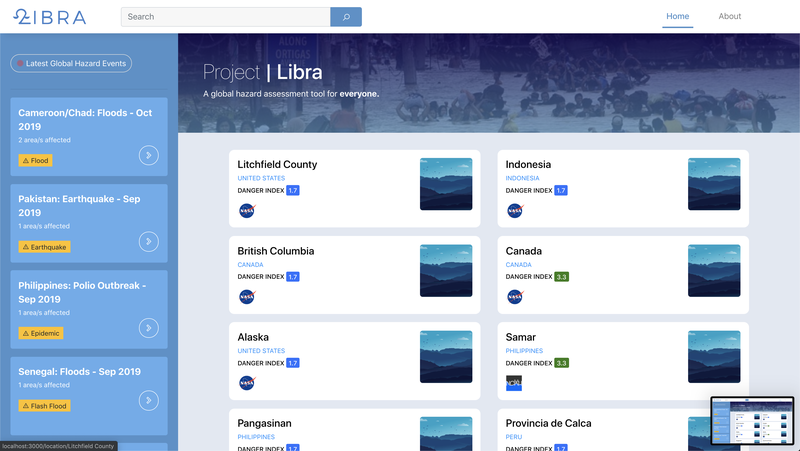
Libra
A disaster assessment platform for everyone! seizing information to combat global hazards.
Background:
Global death rates caused by natural disasters marked 10,000 casualties in 2018. Despite the availability of information, most of the population still has little to no knowledge about the hazards of different places all over the world makes them vulnerable to such danger.
The presence of platforms to inform people about the impact these risks are often too complex and intimidating for most users to engage with.
Solution:
To address this problem, we created Libra a simple and elegant Web platform that utilizes satellite data and other information related to natural disasters, for any users to easily identify the communities that are most vulnerable to different environmental hazards.
We believe that the key to effective disaster risk reduction is the enlightenment about the problem and the ability to truly understand its impact. So we created this platform to help bridge the gaps in the effort to prepare for disasters to come and help humanity move forward.
Main features of Libra:
- Utilizes multiple datasets
- Groups disaster events according to location
- Provides feed of the latest global hazards, epidemics, etc
- Locate each recorded event of disaster per area
- Filter search of the data within the platform
- View details of each event.
Challenges faced:
- Effectively processing each dataset and integrating them into our API.
- Analyzing each JSON objects and extracting relevant information.
- Network latency for importing large amounts of data
Resources:
1.) NASA Landslide data: https://data.nasa.gov/resource/9ns5-uuif.json
2.) NOAH Flood data (Philippines):
http://noah.up.edu.ph/apidocs/floodMaps.html
3.) NOAH Storm Surge data (Philippines):
http://noah.up.edu.ph/apidocs/stormSurgeMaps.html
4.) NOAH LandSlide Data (Philippines): http://noah.up.edu.ph/apidocs/landslideMaps.html
5.) Latest Global Disasters: https://api.reliefweb.int/v1/disasters?limit=10&profile=list&preset=latest
6.) Earthquake data: https://github.com/plotly/datasets/blob/master/earthquake.csv
Project on GitHub:
1.) Frontend: https://github.com/quadroloop/Libra
2.) Backend/API: https://github.com/quadroloop/libra-api
Try Libra now!: