
c.a.w.s.t.o.n.| Spot That Fire V2.0
Project Details
Awards & Nominations
c.a.w.s.t.o.n. has received the following awards and nominations. Way to go!
 Best Mission Concept

The Challenge | Spot That Fire V2.0
phoeNEX
phoeNEX is a community driven firefighting and fire mitigation app
Demo
https://nasaeurope.appspot.com/app
Motivation
We start with a personal story. Back in 2004, I [Marco] started going to Thassos, Greece with my family during summer. Soon enough, it became family tradition and my parents decided to invest some money in this familiar tradition and build a a very small house on the island. Early 2016, a wildfire tore through the island. I wasn't there at the time but I remember recieving a call from my parents that they are being evacuated to a small area by the ocean. The chaos amongst citizens was crazy, and gusts of winds abruptly changed the fire's trajectory. Our house had thankfully survived due to rock walls denoting land property but for example the restaurant we'd often go to is gone and so are multiple whole villages on the island. The picture bellow was taken by my parents and I heard from them about how chaotic the whole evacuation was. As a result, this challenge particularly attracted me, as well as my teammates due to its intriguing technical challenge.

Background
Wildfires aren't something that happens just to a single Greek island. They indirectly kill over 400,000 people annually due to smoke inhalation, as well as a further few thousand due to direct contact with fire. The four major factors that affect the way that fire spreads are wetness, fuel, slope and lastly wind. The aim of this project was to increase community involvement in the fire mitigation process (without directly increasing their exposure to the fire) to provide emotional and physical support in affected and communities and gather intelligent data wildfire data to aid fire fighting services while supporting the crucial spread of verified information from authorities'.
Philosophy
phoeNEX (pronounced phoenix) is a solution to this year's challenge which focuses on enabling citizens to help each other, to aid authorities and fire fighters and providing information to keep citizens out of danger. We see a huge potential in using distributed information gathering on wildfire development and general circumstances in emergency events which could help authorities make informed decisions to save lives. However, our solution respects and even seeks to assists the hierarchical nature of information distribution in times of public distress and the danger of inaccurate reports spreading to the public. This is why we have developed our unique Emergency interface for authorities described further below. In essence, we hope that with phoeNEX the private sector will be able to give back to the public sector and encourage co-operation and improve human well-being.
Overview of our build
The Interface for Authority and Fire Departments
Through conversations with a Wildfire expert at UCLA, our preconceptions regarding the importance of centrally organized emergency news and plans were confirmed. The said expert argued that many countries have very strict regulations in order to ultimately have one well-informed person who passes down news, escape routes and strategy in a hierarchical chain of command that is tightly checked. This is for the simple reason that information must be double and even triple checked when it comes to life and death scenarios in wildfires.
With phoeNEX, we didn't want to build an app which uses social media features and crowd reporting to introduce unreliable reports, escape routes and other information spreading in affected communities. Because of this, we see important factors of the app such as wildfires, burning areas and evacuation zones to only be reliable if confirmed or entirely dictated by authorities. Thus, we built our Interface for Authority and Fire Departments which serves to give one persistent data stream to send out information in a more modern and efficient way compared to radio, tv and Twitter accounts. Additionally, the interface integrates our machine learning models and data received from users of phoeNIX which can arm these actors with more knowledge. In this vein, a feature we are extremely excited to develop further is the "Drone" feature in the app below in which fire departments or authorities can request drone imagery of affected areas taken by citizens that have appropriate devices. In this way, information can be gathered faster and on a broader scale.
The App
Team c.a.w.s.t.o.n. approached this problem by building a web and mobile app. phoeNEX uses a combination of NASA's Landsat 8 data and FIRMS data to geographically locate and track fires. In addition, machine learning was used to predict the spread of an existing fire based on the Normalized Difference Vegetation Index (NDVI) calculated from the data set. If time would have permitted, the neural network would have further been trained on wind, slope, and wetness levels to fully account for all factors of fire growth.

[image: https://github.com/rcslaney/NASA-Space-Apps-Spot-The-Fire-v2.0/blob/master/imgs/Slide5.PNG]
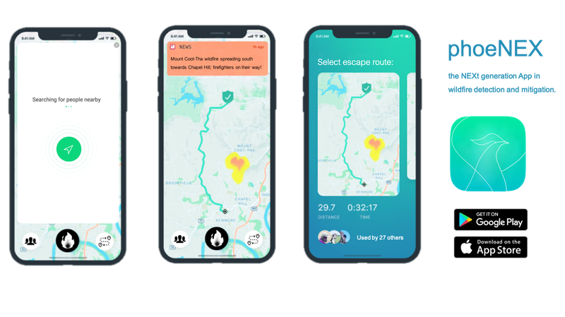
phoeNEX is a progressive web-app that has a minimalistic and simple user interface to accommodate for users of all ages. The homepage displays both the user's and wildfire's location and consequently calculates whether or not the user is at RISK or can offer HELP. Ontop of the homepage there is a NEWS banner that serves to always keep the victims up to date with the latest advancements of the fire. In the case of users in imminent danger, the app would sound an alarm to further increase awareness (this is particularly useful for night fires). Our public API accommodates both the front end as well as back end data collection for local firefighting services and governments. Three main buttons allow for: fire reporting, community help, and rescue services:

[image: https://github.com/rcslaney/NASA-Space-Apps-Spot-The-Fire-v2.0/blob/master/imgs/Slide6.PNG]
Distributed Information Gathering - Fire Reporting
In the event of a newly discovered fire, the central button allows for users to upload a picture of the fire and a brief description to warn local firefighting services. A built in neural network determines the validity of the picture and consequently directs it to local firefighting services.
Local Community Social Emergency Network - Community Help
The community button allows users to not only interact with each other, but to also offer/request for help depending on the users location. By then clicking the messaging button, users can broadcast their risk level to close family and friends, as well as have the opportunity to message people based on their proximity. The help button displays the members of the public most affected by the fire who are requesting for help. Lastly, the safe house button, allows for the SAFE users to crowd-report their homes to accommodate the displaced users in the RISK zone. This generosity The integration of the community not only aims to relieve the social and mental burdens associated with a wildfire, but ultimately reduce the number of injuries/deaths.
Life-saving Advice and Rescue Pathing - Rescue Services
The rescue button also possess three further sub-buttons. The fire safety information button offers users general information about wildfires and how to best mitigate them. This is included in the app to increase user preparedness for a potential future wildfire. The route plan button uses an algorithm to automatically determine safe rescue paths to direct users to a safe area away from the fire. Furthermore, Augmented Reality is used to best navigate the user away form the fire and towards a safe zone. The best path is automatically suggested depending on the approval of previous users. Lastly, the drone button offers the fire department to ask for drone footage of the wildfire, eliminating premature deployments of aircrafts/helicopters.

Augmented Reality
One fascinating technological feature included in phoeNEX is the ability to fetch stored Points of Interests such as safe-houses or municipality buildings, safe zones/evacuation areas, user reports on their environment and overlay this on the real world using a mobile phone camera and the web AR-toolkit AR.JS. Research shows that many deaths and unwanted circumstances in any emergency are due to panic and distressed emotional states causing errors in judgement. With the help of AR, escaping a wildfire, finding another citizen in need of help or finding the closest medical facilities can be without any significant pathing or thinking from the user of the app. Instead of having to look at heat maps on your phone when driving away from a fire, you could instead look through the camera and see a distance to the fire front. This feature has endless possibility and will eventually be integrated completely with every other feature such that everything that goes on in the app is reflected in Augmented Reality.

[image: https://github.com/rcslaney/NASA-Space-Apps-Spot-The-Fire-v2.0/blob/master/imgs/Slide7.PNG]
'' phoeNEX, the NEXt generation of WILDFIRE detection and mitigation. ''
Please note that the above slides of phoeNEX are mockups, for the full progressive web app, please visit our github . Thank you!
List of Resource used:
- Google images for data set of wildfires
- Machine Learning
- Pytorch used to train the models
- NASA DATA: FIRMS and Landsat 8
App build:
- Google Cloud
- MySQL
- Python Flask
- HTML 5
- CSS3
- AR.js
- Google's app engine.
Graphic Design:
- Google images
- Adobe Photoshop
- Microsoft Powerpoint
Repo
https://github.com/rcslaney/NASA-Space-Apps-Spot-The-Fire-v2.0