
Earth Doctor| Spot That Fire V2.0
Project Details
The Challenge | Spot That Fire V2.0
Fire map
Try to find out the fire early by NASA high technology and put it out early. Co-work together ! California people, you will WIN !
Project : Fire map
Member :Hsiao-Chung Lee
Brief Introduction
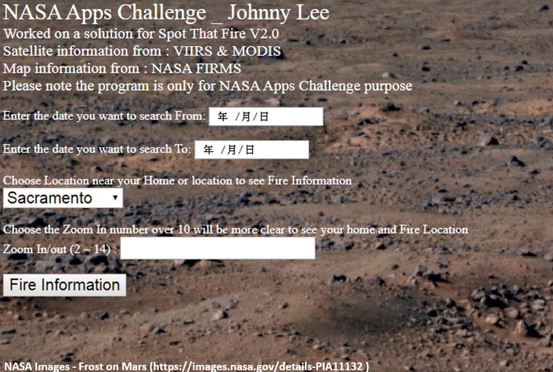
(1)What purpose :Pay attention to the abnormal temperature near your home and notify the local fire station
(2) How to achieve the goal : Use HTML & JavaScript to choose location and date , via NASA FIRMS to find abnormal situation near your home
Fire fighting war declaration
The solution “Fire map” is important for California citizen. We thought that a forest fire appeared in the forest, but in fact it is near us. So we need a system to find fire or sign and share information to related Fire department and peoples.
Currently the program enter some options, those options are some towns close to Los Angeles and the forest. Maybe it’s possible to use smartphone to identify positioning in the future
Try to find out the fire early by NASA high technology and put it out early. Co-work together ! California people, you will WIN !
GitHub : https://github.com/Johnny1029/space-apps-challenge...
Please note : The code/project is only for NASA Space Apps Challenge 2019 (Hackathon), it is not a real product.
Resources used from NASA , Google and Youtube :
NASA's Aqua Satellite Celebrates 10th Anniversary (https://images.nasa.gov/details-GSFC_20171208_Archive_e001778 )
2013 Yosemite Fire Assessed by NASA Satellite Data (https://images.nasa.gov/details-PIA18795 )
Firm – Fire information for Resource Management System (https://firms.modaps.eosdis.nasa.gov/map/#z:3;c:-52.8,39.5;t:adv-points;d:2019-10-07..2019-10-08;l:firms_viirs,firms_modis_a,firms_modis_t )
Visible Infrared Imaging Radiometer Suite (VIIRS) (https://earthdata.nasa.gov/earth-observation-data/near-real-time/download-nrt-data/viirs-nrt )
Google Map (https://www.google.com.tw/maps/place/Deer+Lake+Hig... )
NASA Images - Frost on Mars (https://images.nasa.gov/details-PIA11132 )
Youtube Free Music - login (https://youtube.com )
Tags : #Taipei, #JavaScript , #HTML, #Aqua, #Terra, #Modis, #VIIRS,