
Earth Doctor| Spot That Fire V2.0
Team Updates
Very tired, now is AM 3:45, video been uploaded to Youtube, it's cool.
Although I can try to find some member (they are not in my country), I finally decided that I will finish this task alone.
I am exciting to see live video from NASA Space Challenge Brazil !
# We are the world
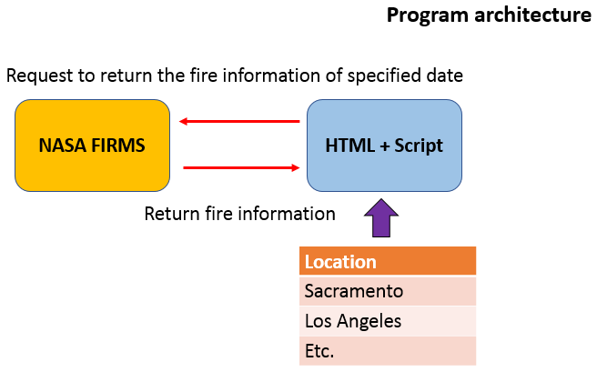
| Choose Location near your Home or location to see Fire Information(now only for L.A.) | |
| <br> | |
| <select name="Location" id="Location" style="font-size:20px" > | |
| <option value="-118.539,34.291">Granada Hills</option> | |
| <option value="-118.590,34.278">Porter Ranch</option> | |
| <option value="-118.483,34.307" selected="selected">Sylmar</option> | |
| <option value="-118.453,34.288">San Fernando</option> | |
| <option value="-118.558,34.239">Northridge</option> | |
| <option value="-118.639,34.254">Chatsworth</option> | |
| <option value="-118.390,34.231">Sun Valley</option> | |
| <option value="-118.332,34.195">Glendale</option> | |
| <option value="-118.171,34.193">Altadena</option> | |
| <option value="-118.066,34.168">Sierra Madre</option> | |
| </select> |
Resources used from NASA and Google
NASA's Aqua Satellite Celebrates 10th Anniversary (https://images.nasa.gov/details-GSFC_20171208_Archive_e001778 )
2013 Yosemite Fire Assessed by NASA Satellite Data (https://images.nasa.gov/details-PIA18795 )
Firm – Fire information for Resource Management System (https://firms.modaps.eosdis.nasa.gov/map/#z:3;c:-52.8,39.5;t:adv-points;d:2019-10-07..2019-10-08;l:firms_viirs,firms_modis_a,firms_modis_t )
Visible Infrared Imaging Radiometer Suite (VIIRS) (https://earthdata.nasa.gov/earth-observation-data/near-real-time/download-nrt-data/viirs-nrt )
Google Map (https://www.google.com.tw/maps/place/Deer+Lake+Hig... )
NASA Images - Frost on Mars (https://images.nasa.gov/details-PIA11132 )