
NASA ALL| Spot That Fire V2.0
Project Details
The Challenge | Spot That Fire V2.0
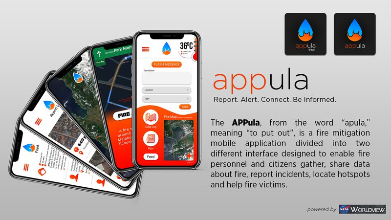
APPula
from the word “apula,” meaning “to put out”, is a fire mitigation mobile application divided into two different interface designed to enable fire personnel and citizens gather, share data about fire, report incidents, locate hotspots and help fire victims.
THE PROBLEM
In the first two months of 2019, 2,229 fire incidents were reported in the Philippines alone. Nearly P7.9 billion pesos was the cost of damage in 2017 in the country due to fire incidents. Contributory factors for the increasing amount of fire incidents locally includes late arrival of fire trucks, ease of reporting fire incidents, and improper tracking of fire hotspots and its causes.
The occurrence of wildfires has been on the rise. Recent trends show that summer and spring seasons now are getting warmer and is projected to get warmer in the future; the number of climate-change-induced fires are getting more prevalent.
With the aggravating effects of the rapid changing of climate, wildfires have increasingly been becoming a norm; a testimony of this would be the Amazon forest fires that shocked the world.
In the Philippines and Asia-Pacific
Fire incidents are usually man-made in the Philippines, the top three causes are due to electrical connections, lighted cigarette butts, and open flames. The Bureau of Fire Protection (BFP) is undermanned and there are firefighters receiving less benefits, the response time is affected by the seemingly perpetual heavy traffic in cities especially Metro Manila.
Some countries in southeast Asia still practice the slash and burn method of clearing lands causing thick haze that cover the atmosphere as seen on the NASA image captured using VIIRS (visible Infrared Imaging Radiometer Suite) Instrument that detected fires burning in southeast Asia on March 17, 2019.
In the U.S.
The wildfire season in California last year had been the most destructive and costly in history and it will continue to worsen in the coming years due to global warming. According to the National Fire Protection Association in the U.S., every 24 seconds, a fire department responds to a fire incident somewhere in the nation. In addition, according to the U.S. Department of Interior, as many as 90 percent of wildland fires in the U.S. are man-made.
Fires are also essential to forests, as it returns nutrients back to the soil and nurtures the growth of some tree species, such as that of Black Spruce in Canada’s Boreal Forest. However, due to the fast warming of the global climate, evidence suggests that frequent and more intense forest fires are harmful in the long run.
In Brazil and the Amazon
Occurrence of forest fires in this region varies substantially (most specifically in Brazil, Bolivia, Peru and Colombia) and is usually low due to the fact that it is mostly rainforest and is wet for most of the year but its risk of forest fire increases during the peak of the dry season, but according to the data from NASA Earth Observatory, using Moderate Resolution Imaging Spectroradiometer (MODIS), 2019 has shown a record number of forest fires that were not just exacerbated by the regional drought but also by the economic activities of land burning for commercial use in pastures and land farming.
OUR SOLUTION
The APPula, a fire mitigation mobile application, is designed to enable fire institution and citizens gather and share data about fire, report incidents, and help victims of fire. It is divided into two different interfaces. The first interface helps fire institution to be notified whenever fire reports have been made from a nearby area by a citizen. Traffic congestion caused by fire incidents and obstruction of roads and narrow streets will not be a problem anymore for fire trucks and drivers using the real-time map showing the best and safest routes. A fire map feature is also included in the app which incorporates NASA Worldview data to show a real-time map showing fire occurrences within the day. A data logger from the app will collect data to gather fire hotspots over the years and it will include the full details of specific fire incidents that will be input by the fire institutions. The second interface is designed for citizens. This interface will help citizens report fire incidents in a click, be notified of nearby fire incidents, drive in ease during times of fire nearby, and send donations to victims of fire and help aid the needs of the victims through crowdsourced donations. It may also be applied to countries with incidents of wildfire. The APPula with the incorporation of NASA data is envisioned to be a great contribution to fire mitigation techniques since we are already living in a world full of varied technologies.
Features of APPula
For the APPula Dept:
- An alert system for fire incidents
- A data log of previous fire incidents that the fire institutions will input
- A report log containing previous fire incident reports by the general public
- Feed of real-time news and updates of fire-related incidents
- Fire Map powered by NASA Worldview
- Post feature for posting real-time updates on the present condition of the incident
- Weather feature that will show factors affecting the spread of a fire (wind direction, relative humidity and temperature)
- A "lead me to safety" map showing the safest routes away from the fire.
For the APPula:
- A report feature that lets the citizens report a fire-related incident
- A daily fire safety and prevention tip
- A directory of fire station hotlines arranged based on different locations
- A data log of previous fire incidents that the fire institutions will input
- A "favorites" feature that lets a citizen to choose favorites from the directory for quicker access to call for help in an event of fire
- Alarm system when the fire institution released an alert of fire incident
- Fire Map powered by NASA Worldview
- A "post" feature as well for posting updates
- A feed of real-time news and updates of fire-related incidents
- Weather map that will show factors affecting the spread of a fire (wind direction, relative humidity and temperature)
Related Literatures
Info from Bureau of Fire Protection
Through Smoke and Fire, NASA Searches for Answers
Resources Used
Platforms Used
Figma (APPula Dept. Prototype, APPula Citizens Prototype)
Adobe Premiere Pro
Adobe Photoshop
Google Drive
Problems Encountered
None of us team members are proficient in coding. We focused mainly on the user interface and prototyping of the APPula. Another difficulty we have encountered is how we would incorporate the NASA data on our application, since we also had difficulty in making our ideas concrete. Our ideas were so complex in the beginning and incorporating NASA data seemed confusing.