
The Mars Society Chile| Spot That Fire V2.0
Project Details
The Challenge | Spot That Fire V2.0
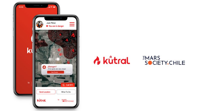
Kutral
Kutral wil be a tool for the prevention, detection, and prediction of wildfire. Using both meteorological and satellite data, Kutral will present the prediction of the fire track, sending a notification alert to the user in case they need to evacuate.
Background
In Chile, 99,7% of the wildfires are produced by human causes (CONAF). There are also natural events that can cause fires, such as dry climate, lightning, and volcanic eruptions.
In the Chilean summer of 2018 and 2019, fires consumed 624.100 hectares. The magnitude of the fires increased since the 30-30-30 rule was reached: winds above 30 km/h, temperatures above 30 degrees Celsius, and relative humidity under 30%.
Worldwide, more than 3 million hectares were burned this year. This year we witness the worse wildfire produced in the Amazon Forest, home of 40.000 plant species, 1.300 types of birds, and 426 different mammals (source: Amazon wilfires).
The Amazon Rainforest reaches 7,000,000 km2 covering a total of 9 countries, around 40% of the total area of South America. Brazil has 60% of the total Amazon rainforest area in its territory. Unfortunately, 17% of its area has been lost due to forest fires in the last 50 years.
The leading cause of these fires is due in large part to the illegal "cleaning" of land to create more farms. Brazil is the 2nd world producer of meat. However, forest fires put its economy at risk. European companies that want to generate trade agreements with Brazil, often give up on the negative reports they receive about the Amazon. Many of these companies seek to reduce their carbon footprint, so fires in the Amazon contradict their policies.
Fires also produce supply problems. Many companies use the resources provided by the Amazon as mineral or the endemic flora used as a base for many pharmaceutical drugs.
Fires also generate a global environmental impact. The Amazon rainforest can absorb more than 20% of atmospheric CO2, which transforms into oxygen, fulfilling a natural function to maintain the balance of emissions. However, a fire produces carbon monoxide, nitrous oxide, among other toxic compounds, which are released into the atmosphere. Besides contaminating, fires destroy trees capable of maintaining balance on the planet and change their surface conditions as emissivity, albedo, and hence its surface energy budget.
Due to the high impact generated by fires in the world, we propose the following solution based on the following objectives:
- Predict danger zones during wildfire events, using meteorological variables and remote sensing information.
- Visualize predictions in both a web platform and mobile app.
- Generate alerts to cell phone users when conditions and the predicted danger zone is near.
Resources and Methodology:
For predictions, we use both meteorological data from the Global Forecast System (GFS), specifically surface temperature, relative humidity and wind (magnitude and direction), and satellite data from MODIS land products for vegetation index, and burned area from FIRMS.
The methodology involves monitoring meteorological variables looking to identify danger zones and predicting the trajectory of the fire.
For visualization, we create web and mobile applications to generate alerts, showing the results of the predictions, besides the historical data and evolution of the event.
The predictions are used to generate alerts for mobile and web apps. With our app installed, the user will receive a notification about the danger around the area.
Our case study is the Brazilian Amazon. Its wildfires are usually produced in the dry season, between July and November, generating a global environmental impact. The Amazon rainforest can absorb more than 20% of atmospheric CO2, which transforms into oxygen, fulfilling a natural function to maintain the balance of emissions. However, a fire produces carbon monoxide, nitrous oxide, among other toxic compounds, which are released into the atmosphere. Besides contaminating, fires destroy trees capable of maintaining balance on the planet and change their surface conditions as emissivity, albedo, and hence its surface energy budget (INPE).
Under this consideration, we develop a demo based on meteorological and satellite data for August 4 until August 20, 2019.
In the future ...
We plan to incorporate analysis through machine learning and artificial intelligence that allows us to delimit and better characterize the meteorological and land use parameters that promote the spread of fires.
We will include the option for pictures, so the user can send a report of the situation, in situ. In addition, we will include information about the institutions that are enabled to face the emergency.