
Space Makers| Eeny, Meeny, Miney, Sample!
Project Details
The Challenge | Eeny, Meeny, Miney, Sample!
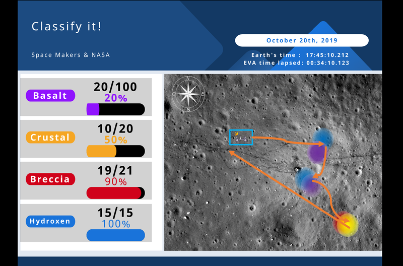
Clasify it!
“Classify it!” is a portable device with sensors like Alpha Proton X-Ray Spectrometer that processes rock samples to analyze, classify and store them into known categories of lunar rocks. It uses NASA’s data and future GPS in Moon for mission planning
Clasify it!
What does it detect?
“Classify it!” can identify and sort the main classifications for rock samples like Basalt, Crustal, Breccia and some of their subcategories in a short time. Moreover, it is made so that you can use more sensors to obtain more data from the samples when sorting them.
Sorting
The device receives a constantly increasing amount of raw rock samples that astronauts collect in a certain location, then uses an Alpha Proton X-Ray Spectrometer (APXS) similar as the one used in the Curiosity Mars Rover to get a representative amount of the chemical components of the sample in 10 minutes (at this point the device should be able to process more information from the sample with more sensors to find Hydroxide or weighing the sample with inertia balance). For every sample analyzed, the device takes the sample into a sample bag, seals the bag, and stores it in a container ready to take back to Earth. At the same time the sample was analyzed, the program takes the extracted chemical information and “Lunar GPS location” (Artemis Project plans to implement GPS satellites for next Moon missions) and stores this information into NASA’s databases for Mission Planning and Control.
Use of massive amounts of data for Mission Planning & Control
This artifact does not only sorts samples, but also helps taking advantage of big amounts of data, for example, each of the sensor-mapped images of the Moon GPS location are part of the complementary development of this project, which is an interface for astronauts that processes historic NASA Moon data, including apollo missions, and gives the Lunar crew a Map of the Moon tracking their current position and showing in real time potential exploring locations and paths to follow to find certain types of samples.
In short improvements summary for this challenge
“Classify it!” contributes to this problem as follows:
- Reduces EVA time by preventing astronauts spend time selecting and storing samples. In fact, the device could be attached not only to the rover, but also to the base ship and keep processing captured samples even when astronauts have returned from EVA.
- Reduces the amount of samples taken by selecting only the ones worth collecting, the rest are put away from the container back to Moon’s surface.
- Uses NASA historical data from apollo and related missions, Moon samples data, and GPS location in real time to generate an interface for the crew in EVA to follow mission paths depending on the sample’s capture priority.
References
Sensors and classification
Moon land understanding sources
https://www.lpi.usra.edu/publications/books/lunar_sourcebook/pdf/LunarSourceBook.pdf
Mars Curiosity sensors
https://mars.nasa.gov/msl/spacecraft/instruments/summary/
Sensor Alpha Proton X-Ray Spectrometer (APXS) en Curiosity, “The proton spectra for alpha particles interacting with elements with atomic numbers from 9 to 14 are very characteristic of the individual elements, reflecting the resonance nature of the nuclear interactions involved”
https://mars.nasa.gov/MPF/mpf/sci_desc.html#APXS
Planned sensors to bring for next missions to the Moon
https://www.nasa.gov/press-release/nasa-selects-experiments-for-possible-lunar-flights-in-2019
Designs
Bag seals
https://www.youtube.com/watch?v=_sJHMEzaUPg
Sample containers used in apollo missions
https://www.lpi.usra.edu/lunar/samples/apollo/tools/images/box2_lg.gif
https://www.lpi.usra.edu/lunar/samples/apollo/tools/images/box_lg.gif
Database sources
Apollo Missions Journals. We noticed how much time they spent deciding between taking one or another sample talking between astronauts, delaying the mission.
https://www.hq.nasa.gov/alsj/main.html
Geology catalog of instruments in Apollo missions
https://www.hq.nasa.gov/office/pao/History/alsj/tools/Welcome.html
https://www.lpi.usra.edu/lunar/samples/apollo/tools/index.shtml
https://www.lpi.usra.edu/lunar/missions/
Past moon samples
https://curator.jsc.nasa.gov/lunar/samplecatalog/index.cfm
Collection points for past samples on Apollo missions
https://curator.jsc.nasa.gov/lunar/catalogs/other/lunar_soils_catalog.pdf
Apollo missions landing marks
https://www.nasa.gov/images/content/346619main_moonimg_07_full.jpg
Hydroxen in the Moon
https://es.wikipedia.org/wiki/Agua_lunar
https://commons.wikimedia.org/wiki/File:Chandrayaan1_Spacecraft_Discovery_Moon_Water.jpg
How locations for samples were taken in apolo missions
https://curator.jsc.nasa.gov/lunar/catalogs/other/a16_special_samples.pdf